Tamolitch Blue Pool Hike in Oregon
The Tamolitch Blue Pool Hike in Oregon, AKA Tamolitch Falls Blue Pool, is a spectacular, pristine turquoise blue pool with a seasonal waterfall. It is hidden in the Willamette National Forest on the McKenzie River in Linn County. So, in this post, we share handy tips about the Tamolitch Blue Pool Hike, which is fabulous. It’s one of the prettiest and best hikes in Oregon. How to get there, how long is the hike, and what to expect? Check our hints.
This article may contain affiliate / compensated links. For full information, please see our disclaimer here.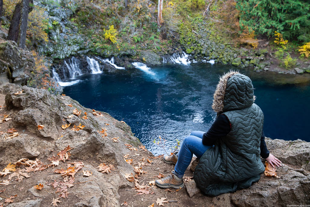
Tamolitch Blue Pool Hike Quick Overview
Level Difficulty and Time Required for Tamolitch Blue Pool Hike
Level: Easy to Moderate. It’s quite a short hike, but it might be rough and challenging due to the rocky terrain, so take proper hiking shoes with great traction. It could be slippery.
Hiking Distance: From Trailbridge Reservoir is 4.2 miles out and back.
Elevation Gain: 375 feet.
Approximate Hike Time: 1 hour and 30 minutes one way.
Best Season and Permits for Tamolitch Blue Pool Hike
Best Season for Visit: Spring, due to the highest water level and the most beautiful waterfalls. And Fall because of the wonderful fall foliage, great weather, and fewer crowds. The busiest season is from June to August.
Best Time To Go: Most tourists are on weekends, so it’s better to go during the week or early in the morning.
Permits: There are no permits required.
Fee: No Fees. $0.00.
Accessibility and Services at Tamolitch Blue Pool
Accessible: year-round. It’s also accessible for mountain bikers, so share the trail carefully.
Family-Friendly Hike: Yes
ADA accessible: No
Pets-Friendly Hike: Yes. Dogs must be kept on a leash.
Services: no facilities such as drinking water, garbage, or restrooms exist. So, prepare for your hike, pack all your trash, and practice Leave No Trace principles during your visit.
Closest Towns: McKenzie Bridge, Oregon.
Our Experiences
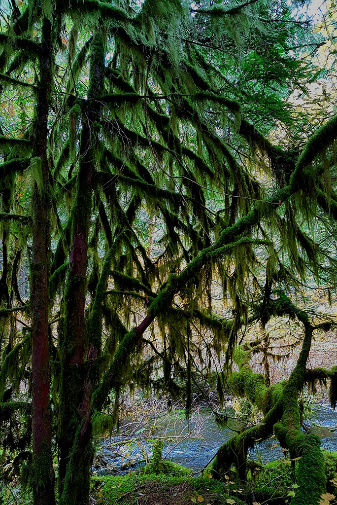
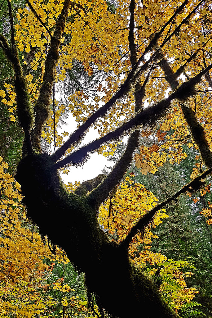
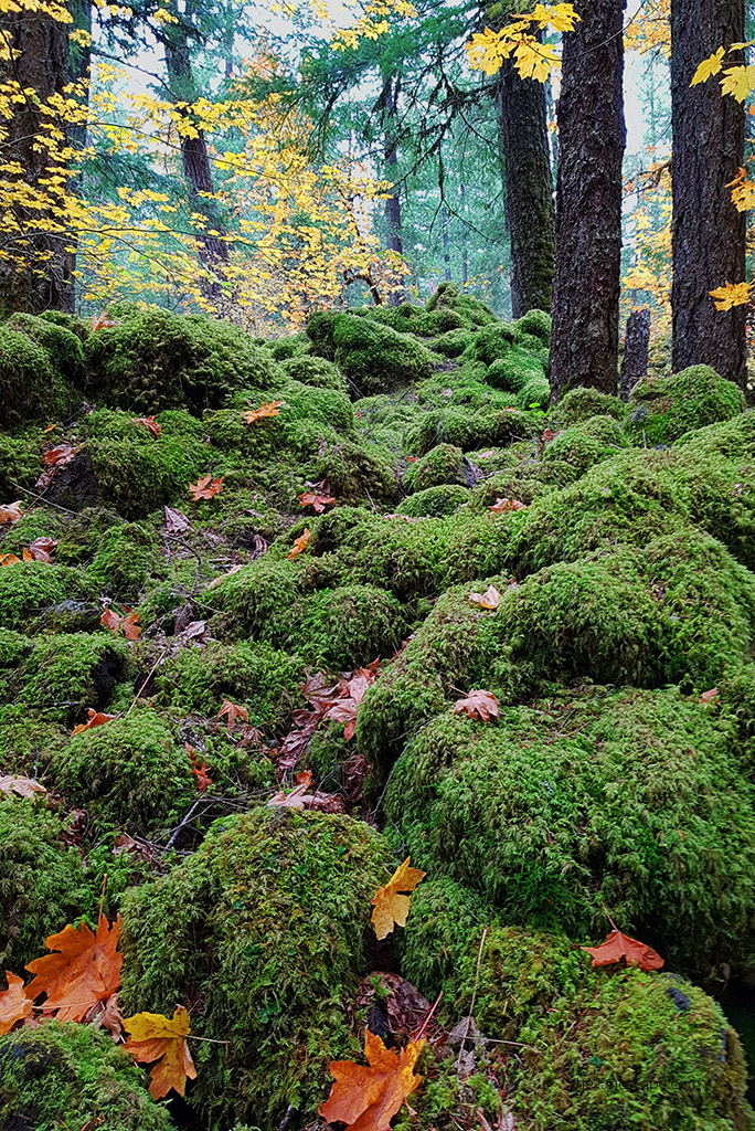
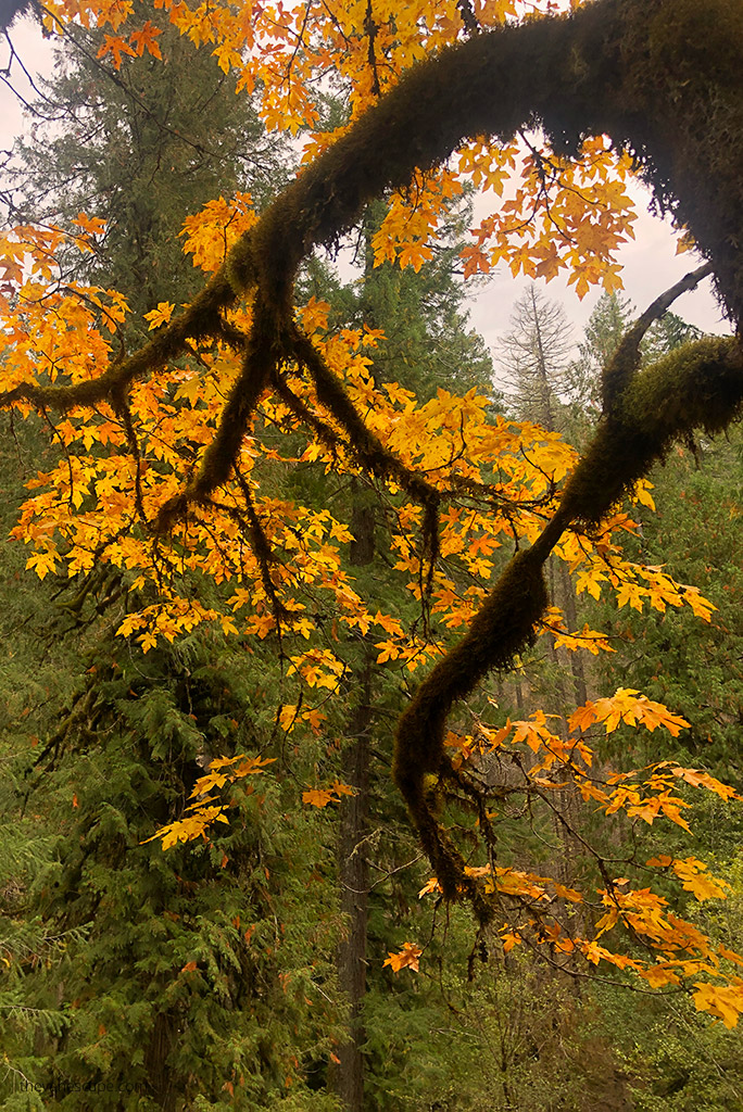
My partner Chris and I did this hike in the fall during one of our Oregon road trips. The scenery was fabulous, as the colorful autumn leaves surrounded us in shades of yellow and orange. The hike wasn’t challenging, but the trail goes through the thick old forest, so it’s shaded and chilly.
Even in summer, it’s worth packing something warmer because it will be colder in the middle of the forest. The article shares our observations, first-hand experience, and tips. All photos presented in this article are ours.
What is Tamolitch Falls Blue Pool?
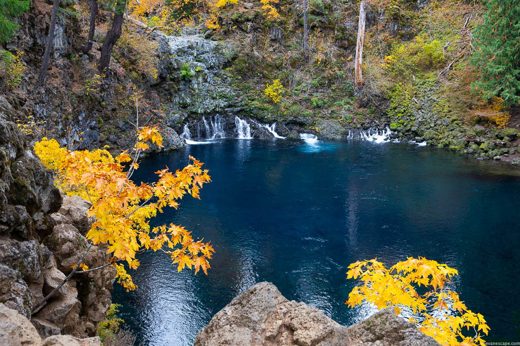
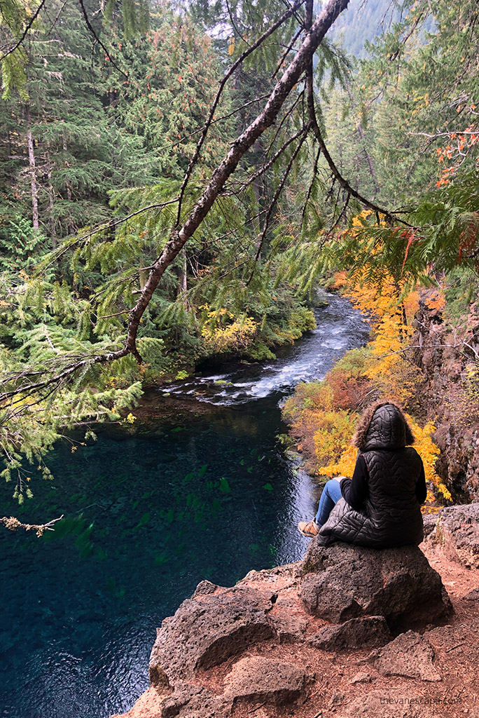
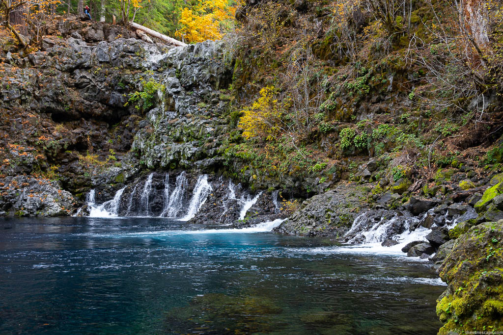
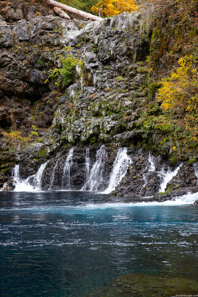
Tamolitch Falls, also known as Blue Pool due to its amazing blue watercolor, is a popular hiking spot in Willamette National Forest, Oregon. The deep turquoise and stunning clarity of the Blue Pool make this place unforgettable.
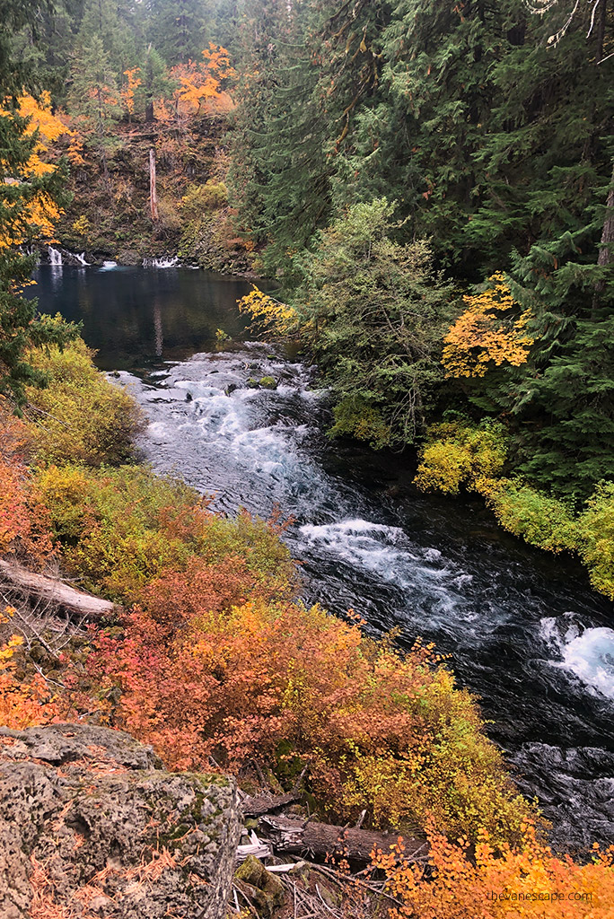
This cliff-rimmed basin with stunningly clear water looks fabulous from the top when you stand over the edge. The steep cliffs surrounding the Blue Pool are 10-60 feet tall, so be careful not to trip over and jump from this height into the water. It might be dangerous.
Blue Pool Hike is a short section of the McKenzie River National Recreation Trail, which runs from Trail Bridge Reservoir north along the McKenzie River. The Trail is 26 miles long and perfect for mountain biking.
The McKenzie River area is full of amazing places, like Koosah Falls, Sahalie Falls, or the fabulous and our favorite Proxy Falls.
Furthermore, Tamolitch is an excellent photographic spot. Blue Pool Hike offers lots of photo subjects, such as reflections of the water, the alder trees, the lichens and moss, the downed trees, and more.
Where is Tamolitch Blue Pool Hike?
Tamolitch Falls Directions from Bend
The total distance from Bend is 63 miles, and it will take approximately 1 hour and 10 minutes to drive. Drive on US-97 north and take exit 135A to merge onto US-20 West towards Sisters for 20 miles.
In the charming town of Sisters, stay on US-20 West. Then, turn onto OR-126 E for 10.8 miles. Turn right at a sign for Trailbridge Campground/Blue Pool. You must cross a bridge and turn right onto gravel road NF-730. After about a third of a mile, park along the right side of the road.
From Band and Sister is also possible to take McKenzie Pass Scenic Highway number 242 to see some of the Sisters Country’s most spectacular scenery. But route 242 is closed during winter from November to July. So, if you are in the summer, take this route to admire Oregon’s Cascade Mountains.
Tamolitch Falls Directions from Portland
Portland’s total distance to Tamolitch Blue Pool is 138 miles, or 2 hours and 30 minutes of driving. It would be best to drive I-5 south toward Salem. Then, take exit 253 for OR-22 east toward Detroit Lake/Bend.
Drive on OR-22 for 80 miles, then turn right onto US-20 W. Turn right onto OR-126 E. Then turn right at a Trailbridge Campground/Blue Pool sign.
When you cross a bridge, turn right onto gravel road NF-730. After about a third of a mile, park along the right side of the road.
Our Tip: If you are driving from Portland, make sure to check out our Portland itinerary.
How was create Tamolitch Blue Pool?
The area was extremely volcanically active. 1,600 years ago, lava flow from Belknap Crater buried a 3-mile (4.8 km) stretch of the McKenzie River between Carmen Reservoir and Tamolitch Falls, moving that portion deep underground.
The Tamolitch Blue Pool has been created from where the river seeps the surface through the porous lava back above ground as an enchanting crystal-clear lake. In Spring, when the runoff is strongest, Tamolitch Falls flows over the lava.
How deep is the Tamolitch Blue Pool?
The water is so clear that it feels shallow, but the pool’s depth is over 30 feet in many spots.
How cold is the water in the Tamolitch Blue Pool?
The water temperature in Tamolitch Blue Pool is low, on average 37 degrees Fahrenheit (2.8 C).
Can you swim in the Tamolitch Blue Pool?
The water temperatures are frigid. So, swimming is not encouraged or recommended. It’s important to know that you can become hypothermic in less than 10 minutes in such a cold water temperature. Swimming and jumping into the water can turn out to be tragic. It is difficult to call an emergency because there is often no coverage. So, don’t risk it. It’s not a swimming pool.
Is there camping nearby?
There are 14 US Forest Service Campgrounds along the McKenzie River. The Blue Pool Campground (Middle Fork Ranger District) is the closest, open from May 28 to September 20. You can check the details on the Forest Service website. Other campsites in the area you will find in the Willamette National Forest.
But staying overnight in the picturesque and beautiful town of Sisters is worth staying overnight. This post recommends where to sleep and what to do and see in the Sisters area. It’s about 40 miles from Blue Pool Hike.
Tamolitch Blue Pool Hike Detailed Description
Directions to Tamolitch Blue Pool Trailhead
From the McKenzie River Ranger Station, take Highway 126 east 10 miles to Trail Bridge Reservoir. Then you must turn left on FS Road 730 at the sign to Trail Bridge Reservoir. After crossing the river, turn right and travel to the parking area. Start walking slightly uphill to the trailhead sign, and begin walking upstream.
Hike to Tamolitch Blue Pool
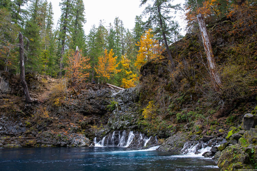
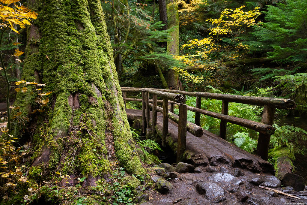
The Tamolitch Blue Pool Hike starts at the entrance of an old-growth forest with gigantic Douglas fir trees dating back more than 500 years. Looking at these ancient mossy trees evokes a fairy tale. The trail is well-marked.
Woodland is dense. You are surrounded by deep green, mossy branches of trees, and the river hum. The path is straight at first, then gradually ascends. It goes along the McKenzie River, along the cliff, so the views are great. You are crossing an old bridge with decaying trees.
You descend into a dry river bed, eventually coming to an old lava flow. Slippery lava rocks can be a problem, so be careful. Some elevation gains might be challenging if it’s wet, but it is not a strenuous hike. It’s also great for families, runners, or mountain bikers.
Accessing the Blue Pool
When you reach the trail’s highest point, you can enjoy the crystal clear water from above or walk down to the reservoir itself. Accessing the water is by hiking over the waterfall ledge and taking the trail down to the pool’s side. The descent leads on large, slippery stones and rocks. It is steep. Therefore, remember to wear shoes with a good grip.
Hiking Tips & Safety Rules
Check out our datailed Day Hiking Packing List to know what we always take for a trail.
- Remember to bring water and snacks. Pack more water than you need, as we use a capacious water reservoir.
- Start your hike early in the morning. It might be crowded later, and you may also have trouble finding a parking spot if you arrive too late.
- Take shoes with excellent grip. Slippery lava rock and tree roots might be dangerous, so don’t wear flip-flops.
- Trekking poles will also be helpful on this hike.
- Share the trail with mountain bikers.
- Pack all your rubbish and take them back with you. Leave No Trace.
- If you are going in the summer, take sunscreen.
- Cliff diving at the Blue Pool leads to death and injuries. Don’t take the risk. There have been fatalities at this place.
- Swimming in such cold water leads to hypothermia; don’t swim.
- Be careful when standing over the cliff while taking pictures. Don’t lean forward; it’s easy to fall. One man fell off the cliff, taking a photo, and he died.
- There’s no Cell Service.
Add other trails & attractions near Tamolitch Blue Pool
If you are planning a road trip to Oregon, you may be interested in the following places which are stunning:
- Proxy Falls – one of the most photographed and beautiful waterfalls in Oregon.
- Sisters – a charming town near Bend with plenty of hiking trails.
- Umpqua Hot Springs is located in the central Oregon Cascades.
- Crater Lake – the only Oregon national park, one of the most beautiful lakes in the world, and the deepest lake in the US.
- Multnomah Falls – the tallest waterfall in Oregon.
- The Alvord Desert – desolate, alien landscape with hot springs.
- Timberline Lodge -the Shining movie location in a picturesque setting of Mount Hood.
We sure never knew there was so much to see in Oregon. The list is growing quite long for when we get back to the west coast. Good to know the Tamolitch Blue Pool hike is easy to moderate. Although I am sure it would take me more than 90 minutes with so many great photo stops. That deep blue water sure is stunning. Especially when highlighted by the fall colours.
Thanks for the details about Tamolitch Blue Pool. The water here looks pristine. Good to know that the hike is short even though it is not too easy, and always happy to know that it is family friendly too. 2.8 deg C water? Whoa, that’s cold. I really wouldn’t even dip my toe in in it! Indeed it looks like a fairytale with all those mossy trees! Gorgeous trail.
Oh wow! What a gorgeous place. I know you said not to swim, but I am sure that a lot of people do when the weather is warmer. It looks so tempting to jump right in!
Wow, Tamolitch Blue Pool looks like a beautiful hidden gem! I always admire your photos. It reminds me of a larger version of Big Dismal in Florida. It is formed by a sinkhole, except its depth reaches about 300 feet! Deceivingly deep! These natural craters are truly magnificent.
That’s such an amazing view from the cliff, with all the fall foliage. Volcanic regions always have the best landscapes. Thank you for all the heads up about the water and the slippery rocks. Could probably save somebody’s life.
Wow! That’s a deep blue color and it’s beautiful. It’s nice that it’s free and one but I hope they are able to preserve this wonderful place once more people come in. Happy to know too that dogs are allowed since I love hiking with my furbaby. Looking forward to visiting in the future.
OMG – the Blue Pool is a photographer’s delight. I most definitely would want to opt for this part of the Oregon trail . Good to know that there is camping there for I think I would like to see this place at different times of the day. You have some stunning pictures there. Am totally envious.
Tamolitch Blue Pool in Oregon is really a spectacular sight with that pristine deep blue water. I loved small waterfalls on it and therefore this whole scene is very photogenic. Good to know that this deep blue pool was created due to volcano. Good you shared swimming is not encouraged here as water is very cold and we cannot ask for help due to less mobile coverage. I would love to camp at Blue Pool Campground in Middle Fork Ranger District as surroundings is very beautiful here.
I’ve read about this blue pool a lot – it seems to be a famous destination. I am now adding it to my US road trip list. It seems like I need a full 4 weeks just for Oregon! Anyway, do you need proper hiking shoes for this hike or sandals are ok? I usually just use my good hiking sandals but I’ve been told it won’t be enough for the blue pool hike? Thanks for your tips!
Well it is easy to see why you say the Tamolitch Blue Pool Hike is one of the prettiest and one of the best hikes in Oregon. It is just so gorgeous! I just love the deep blue, but would never be game to go swimming there given the temperature. Beautiful 3-hour return hike thought and a great tip about getting there early.
https://semaglupharm.com/# SemagluPharm
can you take fish oil with crestor: can crestor help with erectile dysfunction – Crestor Pharm
https://semaglupharm.com/# rybelsus 14mg price
LipiPharm: LipiPharm – lipitor classification
http://prednipharm.com/# Predni Pharm
Atorvastatin online pharmacy [url=https://lipipharm.shop/#]when can i resume atorvastatin after taking paxlovid[/url] Lipi Pharm
http://semaglupharm.com/# Order Rybelsus discreetly
atorvastatin rosuvastatin: Crestor 10mg / 20mg / 40mg online – Crestor Pharm
paxlovid and crestor: Crestor Pharm – side effect rosuvastatin
https://semaglupharm.com/# SemagluPharm
Semaglu Pharm: SemagluPharm – Semaglu Pharm
Predni Pharm: prednisone prices – canadian online pharmacy prednisone
https://semaglupharm.com/# Semaglu Pharm
https://semaglupharm.com/# Rybelsus online pharmacy reviews
LipiPharm [url=http://lipipharm.com/#]LipiPharm[/url] LipiPharm
prednisone buy: PredniPharm – prednisone 50
prednisone over the counter: PredniPharm – Predni Pharm
https://semaglupharm.com/# Online pharmacy Rybelsus
Semaglu Pharm [url=https://semaglupharm.shop/#]Semaglu Pharm[/url] rybelsus vs farxiga
otc prednisone cream: prednisone 50 mg coupon – PredniPharm
Predni Pharm: Predni Pharm – PredniPharm
https://semaglupharm.com/# Semaglu Pharm
SemagluPharm [url=https://semaglupharm.com/#]Semaglu Pharm[/url] SemagluPharm
Lipi Pharm: Safe atorvastatin purchase without RX – Lipi Pharm
https://semaglupharm.com/# Semaglu Pharm
CrestorPharm: CrestorPharm – CrestorPharm
https://semaglupharm.com/# does rybelsus cause sulfur burps
Predni Pharm: prednisone where can i buy – prednisone 300mg
LipiPharm [url=https://lipipharm.shop/#]Lipi Pharm[/url] LipiPharm
CrestorPharm: Crestor Pharm – Crestor Pharm
https://semaglupharm.com/# Semaglu Pharm
Lipi Pharm: Lipi Pharm – Affordable Lipitor alternatives USA
Crestor Pharm [url=https://crestorpharm.com/#]rosuvastatin calcium rosuvastatin 5 mg pill identifier[/url] No doctor visit required statins
lipitor canada pharmacy: Affordable Lipitor alternatives USA – LipiPharm
https://prednipharm.shop/# Predni Pharm
https://semaglupharm.com/# SemagluPharm
rybelsus administration: Semaglu Pharm – how many mg is 5 units of semaglutide
SemagluPharm [url=http://semaglupharm.com/#]Semaglu Pharm[/url] Semaglu Pharm
http://semaglupharm.com/# rybelsus tablets for weight loss
Crestor Pharm: what are the long-term side effects of rosuvastatin – pill identifier generic rosuvastatin 5 mg images
Lipi Pharm [url=http://lipipharm.com/#]Lipi Pharm[/url] Lipi Pharm
canadian online pharmacy prednisone: PredniPharm – Predni Pharm
https://semaglupharm.shop/# semaglutide for prediabetes
can rosuvastatin cause weight gain: Crestor Pharm – CrestorPharm
https://prednipharm.shop/# PredniPharm
Rybelsus side effects and dosage: Affordable Rybelsus price – Semaglu Pharm
https://semaglupharm.com/# semaglutide risks
SemagluPharm: Semaglu Pharm – rybelsus semaglutide
http://semaglupharm.com/# SemagluPharm
LipiPharm: Lipi Pharm – п»їBuy Lipitor without prescription USA
Semaglu Pharm [url=https://semaglupharm.com/#]Semaglu Pharm[/url] No prescription diabetes meds online
Best price for Crestor online USA: CrestorPharm – Crestor Pharm
https://prednipharm.com/# price of prednisone 5mg
https://semaglupharm.shop/# Semaglu Pharm
pill identifier atorvastatin 40 mg tablet [url=http://lipipharm.com/#]LipiPharm[/url] Lipi Pharm
canadian neighbor pharmacy: best canadian pharmacy to order from – legitimate canadian pharmacy online
India Pharm Global: india pharmacy – online pharmacy india
https://indiapharmglobal.com/# indian pharmacy online
India Pharm Global: India Pharm Global – india online pharmacy
canadian drugs pharmacy [url=https://canadapharmglobal.com/#]pharmacy in canada[/url] canadian pharmacy ltd
reputable mexican pharmacies online: Meds From Mexico – mexican online pharmacies prescription drugs
https://medsfrommexico.com/# Meds From Mexico
https://medsfrommexico.shop/# Meds From Mexico
mexico drug stores pharmacies: Meds From Mexico – Meds From Mexico
medicine in mexico pharmacies [url=http://medsfrommexico.com/#]Meds From Mexico[/url] mexico drug stores pharmacies
Meds From Mexico: Meds From Mexico – reputable mexican pharmacies online
https://medsfrommexico.com/# Meds From Mexico
top 10 online pharmacy in india: top 10 pharmacies in india – India Pharm Global
pet meds without vet prescription canada [url=https://canadapharmglobal.shop/#]Canada Pharm Global[/url] canada rx pharmacy world
https://canadapharmglobal.com/# reddit canadian pharmacy
buy drugs from canada: Canada Pharm Global – online canadian pharmacy review
https://medsfrommexico.com/# mexico pharmacies prescription drugs
legit canadian online pharmacy: Canada Pharm Global – legitimate canadian pharmacies
legitimate canadian pharmacy [url=http://canadapharmglobal.com/#]canadian pharmacy 24h com safe[/url] canadian pharmacy no scripts
https://medsfrommexico.shop/# mexican pharmaceuticals online
canadian mail order pharmacy: canada discount pharmacy – canadian pharmacy 365
mexican online pharmacies prescription drugs: mexico drug stores pharmacies – mexico drug stores pharmacies
pharmacy website india [url=https://indiapharmglobal.shop/#]India Pharm Global[/url] India Pharm Global
https://indiapharmglobal.com/# world pharmacy india
https://medsfrommexico.com/# Meds From Mexico
canadian pharmacy 365: legal to buy prescription drugs from canada – canada rx pharmacy world
canadian pharmacy meds reviews: canadian pharmacies that deliver to the us – best canadian pharmacy online
http://canadapharmglobal.com/# canadian pharmacy reviews
п»їbest mexican online pharmacies [url=https://medsfrommexico.shop/#]Meds From Mexico[/url] medicine in mexico pharmacies
Meds From Mexico: Meds From Mexico – reputable mexican pharmacies online
northwest canadian pharmacy: Canada Pharm Global – canadian pharmacy com
https://canadapharmglobal.com/# buy prescription drugs from canada cheap
mexican border pharmacies shipping to usa [url=https://medsfrommexico.com/#]Meds From Mexico[/url] buying from online mexican pharmacy
https://medsfrommexico.shop/# Meds From Mexico
global pharmacy canada: canadian pharmacy no scripts – canadian pharmacy uk delivery
India Pharm Global: reputable indian online pharmacy – indian pharmacy online
https://canadapharmglobal.com/# my canadian pharmacy rx
precription drugs from canada [url=https://canadapharmglobal.com/#]Canada Pharm Global[/url] canadian pharmacies that deliver to the us
reliable canadian online pharmacy: Canada Pharm Global – canadian pharmacies comparison
India Pharm Global: India Pharm Global – India Pharm Global
http://papafarma.com/# Papa Farma
Svenska Pharma [url=http://svenskapharma.com/#]apotek sömntabletter[/url] Svenska Pharma
http://raskapotek.com/# Rask Apotek
drogtest apotek: tretinoin apotek – hur mycket Г¤r 500 ml i liter
efacti 10 mg crema: travocort serve ricetta – recensioni farmacia italia 24
https://efarmaciait.com/# EFarmaciaIt
EFarmaciaIt [url=https://efarmaciait.shop/#]EFarmaciaIt[/url] EFarmaciaIt
vaxpropp huvudvГ¤rk: sittring apotek – hudvГҐrd apotek
https://svenskapharma.shop/# Svenska Pharma
farmaГЁ prodotti: voltaren oftalmico – bactroban nasale immagini
https://svenskapharma.shop/# Svenska Pharma
apotek expressleverans [url=http://svenskapharma.com/#]lansetter apotek[/url] vätskeersättning apotek
farmacia online envГo gratis murcia: farmacias 24 horas cerca de mГ – Papa Farma
https://papafarma.shop/# Papa Farma
Svenska Pharma: apotek magnesium – apotek se mina recept
assistenza scalapay [url=https://efarmaciait.com/#]effimia 63 compresse prezzo[/url] EFarmaciaIt
Rask Apotek: Rask Apotek – Rask Apotek
https://raskapotek.com/# koronavaksine på apotek
https://raskapotek.shop/# kalium apotek
Rask Apotek [url=https://raskapotek.com/#]Rask Apotek[/url] Rask Apotek
EFarmaciaIt: cher senza trucco – estorial equivalente
https://svenskapharma.shop/# Svenska Pharma
contractubex crema opinioni: EFarmaciaIt – capsule medicinali
apotek app [url=https://svenskapharma.com/#]Svenska Pharma[/url] Svenska Pharma
https://svenskapharma.com/# Svenska Pharma
microser a cosa serve: EFarmaciaIt – farmacia spese spedizione gratis
https://papafarma.com/# Papa Farma
polase bustine foglietto illustrativo: EFarmaciaIt – cilodex gocce prezzo farmacia
http://raskapotek.com/# Rask Apotek
vitaminer for hГҐr og negler apotek: pef mГҐler apotek – Гёremidd katt apotek
apotek snabbast leverans [url=http://svenskapharma.com/#]Svenska Pharma[/url] rosmarinolja apotek
EFarmaciaIt: addetto consegna farmaci – EFarmaciaIt
https://papafarma.com/# farmacie near me
Svenska Pharma: Svenska Pharma – Svenska Pharma
Svenska Pharma [url=https://svenskapharma.shop/#]Svenska Pharma[/url] apotek nät
http://svenskapharma.com/# Svenska Pharma
aquilea melatonina prospecto: Papa Farma – Papa Farma
https://raskapotek.com/# Rask Apotek
para que sirve el citrafleet: diprogenta precio farmacia – Papa Farma
EFarmaciaIt [url=http://efarmaciait.com/#]EFarmaciaIt[/url] punto lax polvere
https://svenskapharma.com/# järn i mat — lista
apotheke line: Papa Farma – dietetica central comprar
Rask Apotek: mГҐle blodsukker pГҐ apotek – henna hГҐrfarge apotek
a apotek [url=http://svenskapharma.com/#]schampo fett hГҐr apotek[/url] Svenska Pharma
http://svenskapharma.com/# ilningar i tänderna eltandborste
https://papafarma.com/# Papa Farma
Svenska Pharma: Svenska Pharma – Svenska Pharma
EFarmaciaIt: cialis contrassegno bartolini – EFarmaciaIt
comprar viagra on line [url=https://papafarma.com/#]productos farmacГ©uticos[/url] Papa Farma
https://papafarma.com/# precio diu mirena en farmacia
precio tadalafilo 10 mg: Papa Farma – Papa Farma
dietetica central opiniones: farmacia benidorm cerca de mi – farmacia barato
https://efarmaciait.shop/# onaka bustine miglior prezzo
https://pharmajetzt.com/# PharmaJetzt
Pharma Confiance: oharmacie – Pharma Confiance
Pharma Connect USA [url=https://pharmaconnectusa.com/#]Pharma Connect USA[/url] Pharma Connect USA
PharmaConnectUSA: blink pharmacy – Pharma Connect USA
http://medicijnpunt.com/# pharma online
vente tadalafil 20 mg: Pharma Confiance – 50 g de croquette en verre
MedicijnPunt [url=https://medicijnpunt.com/#]apteka eindhoven[/url] MedicijnPunt
http://medicijnpunt.com/# medicijnen kopen online
Pharma Confiance: parapharmacies en ligne – cialis pharmacie en ligne avec ordonnance
https://medicijnpunt.shop/# medicijnen online
Pharma Connect USA: tesco artane pharmacy – aquatic pharmacy azithromycin
Pharma Jetzt [url=https://pharmajetzt.com/#]PharmaJetzt[/url] apotheke shop
Pharma Confiance: god adulte – Pharma Confiance
http://medicijnpunt.com/# MedicijnPunt
MedicijnPunt: mijn medicijn.nl – medicijnen bestellen apotheek
http://medicijnpunt.com/# Medicijn Punt
apotheken nederland [url=https://medicijnpunt.shop/#]MedicijnPunt[/url] pharmacy nederlands
Pharma Confiance: Pharma Confiance – doliprane en parapharmacie
http://pharmajetzt.com/# PharmaJetzt
posologie betamethasone 0 05: caudalie sГ©rum anti tache pas cher – Pharma Confiance
medikamenten preisvergleich [url=https://pharmajetzt.shop/#]PharmaJetzt[/url] PharmaJetzt
https://pharmaconfiance.com/# test candidose verre d’eau
de apotheek: MedicijnPunt – medicijn recept
online-apotheke versandkostenfrei ab 10 euro: online pharmacy – online apotheken deutschland
https://pharmaconnectusa.com/# Pharma Connect USA
Pharma Jetzt [url=https://pharmajetzt.shop/#]onlineapotheken[/url] Pharma Jetzt
http://pharmaconfiance.com/# distribution de aux grands maux?
parapharmacie la moins chГЁre en ligne: Pharma Confiance – Pharma Confiance
Pharma Connect USA: PharmaConnectUSA – PharmaConnectUSA
us pharmacy cialis [url=https://pharmaconnectusa.com/#]target pharmacy flonase[/url] PharmaConnectUSA
https://pharmajetzt.shop/# PharmaJetzt
eau de lourdes prix: Pharma Confiance – Pharma Confiance
apotheke versandkostenfrei: Pharma Jetzt – Pharma Jetzt
http://pharmaconfiance.com/# caen pharmacie
https://pharmajetzt.com/# pet apotheke
Pharma Confiance [url=https://pharmaconfiance.com/#]Pharma Confiance[/url] pharmacie du soleil
apotheke online kaufen: bestellapotheken – Pharma Jetzt
apotheke venlo: luitpold apotheke online shop – aphotek
https://pharmaconfiance.shop/# pharma o
upsa commande [url=https://pharmaconfiance.com/#]pharmacie delivery paris[/url] Pharma Confiance
shop apotheke versandapotheke: Pharma Jetzt – versandapotheke vergleich
Pharma Jetzt: online apotheke pille – Pharma Jetzt
https://pharmaconnectusa.shop/# viagra phuket pharmacy
http://pharmaconnectusa.com/# Pharma Connect USA
Pharma Confiance [url=http://pharmaconfiance.com/#]ketoprofene cachet[/url] Pharma Confiance
publix pharmacy doxycycline: PharmaConnectUSA – Pharma Connect USA
online pharmacy no prescription needed lortab: warfarin pharmacy protocol – best rated online pharmacy viagra
https://pharmaconfiance.com/# pharmacie générale
Pharma Connect USA [url=https://pharmaconnectusa.shop/#]levitra coupons pharmacy[/url] navarro pharmacy
PharmaConnectUSA: Pharma Connect USA – panadol osteo pharmacy
versand apotheke online: shop apotheker – apotheken produkte
https://pharmajetzt.com/# nutrim kapseln erfahrungen
PharmaJetzt [url=https://pharmajetzt.com/#]medikamente deutschland[/url] apotheke online bestellen
Pharma Connect USA: cialis mail order pharmacy – Levitra Oral Jelly
http://pharmajetzt.com/# gГјnstige apotheke online shop
lotemax online pharmacy: pharmacy rx 1 – Pharma Connect USA
cymbalta pharmacy assistance [url=https://pharmaconnectusa.com/#]Pharma Connect USA[/url] target pharmacy clindamycin
Medicijn Punt: Medicijn Punt – Medicijn Punt
http://medicijnpunt.com/# apotheke
shop apothke: medikamente online kaufen – online apotheke gГјnstig
filtre vieillissant en ligne [url=https://pharmaconfiance.shop/#]Pharma Confiance[/url] Pharma Confiance
online apotheke versandkostenfrei: PharmaJetzt – medikamente bestellen sofort
https://pharmaconfiance.shop/# pharmacie garde lyon 8
Pharma Confiance: flagyl enfant – nez de marche dorГ©
ambien cr online pharmacy [url=https://pharmaconnectusa.com/#]wellbutrin pharmacy prices[/url] PharmaConnectUSA
bestellen apotheek: online drugstore netherlands – medicijnen zonder recept met ideal
http://pharmaconfiance.com/# Pharma Confiance
Pharma Confiance: Pharma Confiance – avis etat pur
Pharma Confiance: Pharma Confiance – pharmacie nationale
online pharmacy tamoxifen [url=https://pharmaconnectusa.com/#]simvastatin at target pharmacy[/url] Pharma Connect USA
https://pharmaconfiance.com/# Pharma Confiance
Pharma Connect USA: can you buy misoprostol pharmacy – PharmaConnectUSA
https://pharmaconnectusa.com/# fincar pharmacy
https://pharmajetzt.com/# Pharma Jetzt
PharmaJetzt: apotheke internet versandkostenfrei – PharmaJetzt
Medicijn Punt [url=https://medicijnpunt.com/#]MedicijnPunt[/url] pharmacy nl
apotheke onlin: PharmaJetzt – online-apotheke top 10
https://pharmaconfiance.shop/# pharmacue
nizoral crГЁme: Pharma Confiance – Pharma Confiance
target pharmacy lexapro cost [url=https://pharmaconnectusa.shop/#]legal online pharmacy review[/url] Aricept
Pharma Confiance: ketoconazole gel shampoing – Pharma Confiance
http://medicijnpunt.com/# Medicijn Punt
https://pharmaconfiance.shop/# Pharma Confiance
Pharma Confiance: pharmacie de garde pilule du lendemain – Pharma Confiance
online pharmacy [url=https://medicijnpunt.shop/#]online recept[/url] MedicijnPunt
https://medicijnpunt.com/# MedicijnPunt
apotheke nl: Medicijn Punt – pseudoephedrine kopen in nederland
pillen bestellen: verzorgingsproducten apotheek – Medicijn Punt
mijn apotheek online [url=http://medicijnpunt.com/#]medicatie kopen[/url] ons medicatie voor apotheken
http://medicijnpunt.com/# Medicijn Punt
Pharma Confiance: Pharma Confiance – monuril quand le prendre
online versandapotheke [url=https://pharmajetzt.shop/#]medikamente deutschland[/url] internet apotheke bad steben
https://pharmajetzt.com/# Pharma Jetzt
Pharma Jetzt: PharmaJetzt – shopaptheke
rx online pharmacy reviews: pharmacy artane castle shopping centre – online pharmacy certification
Voveran SR [url=http://pharmaconnectusa.com/#]PharmaConnectUSA[/url] cialis cost at pharmacy
https://pharmaconfiance.shop/# Pharma Confiance
Pharma Confiance: Pharma Confiance – rhume hanche adulte
Cipro: Pharma Connect USA – online pharmacy rx
https://pharmaconnectusa.shop/# worldwide pharmacy online
doliprane parapharmacie [url=https://pharmaconfiance.shop/#]acheter daflon[/url] Pharma Confiance
apteka internetowa nl: online drugstore netherlands – Medicijn Punt
Pharma Confiance: distribution de aux grands maux? – avis sur grande pharmacie de rennes
https://medicijnpunt.shop/# online medicatie bestellen
Pharma Jetzt: Pharma Jetzt – luitpold apotheke online
online apotheek frankrijk: medicijnen zonder recept met ideal – apteka internetowa holandia
shop apotheke versandapotheke versandkostenfrei [url=https://pharmajetzt.com/#]Pharma Jetzt[/url] Pharma Jetzt
https://pharmaconnectusa.shop/# PharmaConnectUSA
http://medicijnpunt.com/# apotheek online bestellen
Pharma Jetzt: PharmaJetzt – luipold apotheke
medikamente bei: PharmaJetzt – aphotek
online apothele: PharmaJetzt – apotal versandapotheke online apotheke
PharmaConnectUSA [url=https://pharmaconnectusa.com/#]Pharma Connect USA[/url] PharmaConnectUSA
https://pharmaconnectusa.com/# PharmaConnectUSA
does rx pharmacy coupons work: online pharmacy worldwide shipping – canadien pharmacies
https://medicijnpunt.shop/# Medicijn Punt
paraphamarcie: pharmacie des drakkard – efficacitГ© monuril
bradleys pharmacy artane: itraconazole pharmacy – online pharmacy without insurance
https://pharmaconfiance.shop/# brosse à dent électrique sonique
MedicijnPunt [url=http://medicijnpunt.com/#]Medicijn Punt[/url] medicijnen bestellen bij apotheek
PharmaConnectUSA: doxepin pharmacy – Pharma Connect USA
Pharma Confiance: Pharma Confiance – Pharma Confiance
https://pharmajetzt.com/# PharmaJetzt
shopping apotheke: PharmaJetzt – online apptheke
https://pharmaconfiance.com/# Pharma Confiance
MedicijnPunt: online medicijnen kopen zonder recept – Medicijn Punt
PharmaConnectUSA [url=https://pharmaconnectusa.shop/#]Levaquin[/url] Shallaki
Pharma Confiance: Pharma Confiance – pharmacie en ligne allemagne qui livrГ© en france
https://pharmaconnectusa.com/# rhinocort online pharmacy
Pharma Connect USA: australian pharmacy domperidone – empower rx pharmacy
PharmaJetzt: PharmaJetzt – sofort apotheke
medicijn bestellen [url=https://medicijnpunt.shop/#]belgie apotheek online[/url] mijn apotheek
frenadol kopen in nederland: internet apotheek – Medicijn Punt
http://pharmajetzt.com/# PharmaJetzt
https://pharmajetzt.shop/# PharmaJetzt
medicament en w: Pharma Confiance – avis tadalafil
MedicijnPunt [url=https://medicijnpunt.com/#]medicatie kopen[/url] medicijnen online
PharmaJetzt: europa apotheek – shopa
https://medicijnpunt.shop/# Medicijn Punt
Pharma Confiance: caudalie nantes – ggp auto montpellier
PharmaConnectUSA: good pharmacy – PharmaConnectUSA
Pharma Confiance [url=http://pharmaconfiance.com/#]phrmacie[/url] verveine constipation
http://pharmaconfiance.com/# Pharma Confiance
http://medicijnpunt.com/# Medicijn Punt
PharmaConnectUSA: Pharma Connect USA – PharmaConnectUSA
huisapotheek online: Medicijn Punt – Medicijn Punt
boots pharmacy orlistat: sam’s club pharmacy hours – Pharma Connect USA
https://pharmajetzt.com/# medicine online
Medicijn Punt: Medicijn Punt – Medicijn Punt
Tenoretic 100mg [url=http://pharmaconnectusa.com/#]PharmaConnectUSA[/url] dutasteride inhouse pharmacy
apotek online: medicaties – online apotheek 24
http://pharmajetzt.com/# PharmaJetzt
http://canrxdirect.com/# buying drugs from canada
IndiMeds Direct [url=https://indimedsdirect.com/#]indian pharmacies safe[/url] india pharmacy mail order
canada rx pharmacy world: CanRx Direct – onlinecanadianpharmacy 24
adderall canadian pharmacy: canadian pharmacy tampa – canadian pharmacies that deliver to the us
https://tijuanameds.com/# mexican pharmaceuticals online
indian pharmacy paypal [url=https://indimedsdirect.com/#]top online pharmacy india[/url] india pharmacy
TijuanaMeds: mexican online pharmacies prescription drugs – mexican border pharmacies shipping to usa
medication from mexico pharmacy: TijuanaMeds – TijuanaMeds
http://tijuanameds.com/# TijuanaMeds
http://indimedsdirect.com/# reputable indian online pharmacy
reliable canadian online pharmacy [url=https://canrxdirect.shop/#]CanRx Direct[/url] canadian pharmacy 365
п»їlegitimate online pharmacies india: IndiMeds Direct – indian pharmacies safe
http://tijuanameds.com/# TijuanaMeds
vipps canadian pharmacy [url=http://canrxdirect.com/#]legal to buy prescription drugs from canada[/url] legit canadian pharmacy
TijuanaMeds: TijuanaMeds – TijuanaMeds
https://tijuanameds.com/# TijuanaMeds
https://canrxdirect.shop/# canadian discount pharmacy
TijuanaMeds [url=http://tijuanameds.com/#]mexican online pharmacies prescription drugs[/url] TijuanaMeds
77 canadian pharmacy: online canadian pharmacy review – best canadian online pharmacy
http://tijuanameds.com/# TijuanaMeds
pharmacies in canada that ship to the us [url=https://canrxdirect.com/#]CanRx Direct[/url] my canadian pharmacy reviews
ed drugs online from canada: canadian pharmacy store – canadian online drugstore
https://canrxdirect.com/# legitimate canadian pharmacies
https://tijuanameds.com/# TijuanaMeds
buy prescription drugs from canada cheap: canada drugs online reviews – best canadian pharmacy online
https://indimedsdirect.com/# online pharmacy india
pharmacies in canada that ship to the us: canada drug pharmacy – canadian pharmacy world
prescription drugs canada buy online [url=https://canrxdirect.shop/#]online canadian pharmacy review[/url] canadian pharmacy online store
https://rummy-in.com/unlock-the-secrets-of-mastering-rummy-nabob-a-step-by-step-winning-method-14-06-2024/
https://football-pitch-eg.com/d8afd8a7d8b1d988d98ad986-d986d988d986d98ad8b2-d98ad988d8acd987-d8b1d8b3d8a7d984d8a9-d8a5d984d989-d8acd985d8a7d987d98ad8b1-d984d98ad981/
https://l2lb8bqm.com/em-jogo-com-dois-gols-relampagos-ponte-preta-vence-mirassol-e-pressiona-o-palmeiras-no-paulistao/
https://sjmna7bz.com/novo-estadio-do-flamengo-deve-gerar-impacto-de-r-53-bilhoes-na-economia-do-rj-diz-prefeitura/
https://football-boots-eg.com/d988d8a7d8a6d984-d8acd985d8b9d8a9-d983d986d8aa-d8a3d8aed8a7d981-d985d986-d985d987d8a7d8acd985-d8a7d984d8b2d985d8a7d984d983-d988d8aa/
TijuanaMeds: TijuanaMeds – buying from online mexican pharmacy
http://indimedsdirect.com/# Online medicine order
TijuanaMeds: п»їbest mexican online pharmacies – TijuanaMeds
https://football-players-eg.com/d985d988d8a7d8b9d98ad8af-d985d8a8d8a7d8b1d98ad8a7d8aa-d983d8a3d8b3-d8a7d984d8b1d8a7d8a8d8b7d8a9-d8a7d984d985d8b5d8b1d98ad8a9-d983/
best canadian pharmacy [url=https://canrxdirect.com/#]canadian pharmacy world[/url] online canadian pharmacy reviews
https://football-ball-eg.com/d8b5d988d8b1d8a9-d8a7d984d981d8a7d8b1-d98ad8add8b1d985-d8a2d8b1d8b3d986d8a7d984-d985d986-d8a7d984d8b9d988d8afd8a9-d8a3d985d8a7/
https://yalla-kora-live-eg.com/d8a7d984d985d8bad8b1d98ad8a7d8aa-d983d8a8d98ad8b1d8a9-d988d984d986-d8a3d8b3d8a7d988d985-d8a3d988d984-d8aad8b9d984d98ad982-d985/
RxFree Meds: RxFree Meds – RxFree Meds
https://rxfreemeds.com/# domperidone pharmacy online
https://dobrowin-br.com/lucratividade-das-maquinas-caca-niqueis-dobrowin-2023/
diovan pharmacy: RxFree Meds – buy cialis pharmacy
http://rxfreemeds.com/# pharmacy viagra prices
https://22bet-in.com/
https://total-football-eg.com/d984d98ad981d8a7d986d8afd988d981d8b3d983d98a-d98ad982d988d8af-d987d8acd988d985-d8a8d8b1d8b4d984d988d986d8a9-d8a3d985d8a7d985-d8afd988/
Farmacia Asequible [url=https://farmaciaasequible.com/#]cual es el mejor genГ©rico de cialis[/url] Farmacia Asequible
https://enclomiphenebestprice.com/# enclomiphene online
enclomiphene: enclomiphene buy – enclomiphene testosterone
Farmacia Asequible: movicol opiniones – tramadol comprar
https://wfnyyngw.com/qual-e-a-data-de-inicio-da-copa-do-brasil-sub-20-2024/
RxFree Meds [url=https://rxfreemeds.com/#]365 pharmacy kamagra[/url] viagra online mexican pharmacy
https://rxfreemeds.shop/# ranitidine uk pharmacy
https://p504hwt9.com/jose-boto-cobra-fair-play-financeiro-no-futebol-brasileiro/
https://rxfreemeds.shop/# rx relief pharmacy
buy enclomiphene online: enclomiphene citrate – enclomiphene for sale
https://lottoland-br.com/lottoman-o-guia-total-para-iniciantes/
enclomiphene buy: buy enclomiphene online – enclomiphene buy
https://pj5kftrn.com/voce-pode-estar-se-referindo-a-um-jogo-do-vasco-da-gama-na-copa-do-brasil-para-fornecer-a-hora-exata-do-jogo-preciso-saber-a-data-especifica-ou-o-adversario-do-vasco-voce-pode-me-informar-esses-det/
https://7tu1rb01.com/qual-e-a-data-do-sorteio-da-copa-do-brasil-2024/
https://www.bet7k-br.com/
https://oov7cpx9.com/
https://yalla-bar-dahab.com/d8a8d8a7d984d8b5d988d8b1-d8a3d988d986d8a7d986d8a7-d98ad8b3d8aad981d8b2-d8acd985d8a7d987d98ad8b1-d984d98ad988d986/
https://w88-vn.com/w88-f09f92b0-w88-thuong-30k-trai-nghiem-mien-phi/
https://planet-football.com/d8acd988d8a7d8b1d8afd98ad988d984d8a7-d984d98ad981d8b1d8a8d988d984-d984d8b9d8a8-d8a8d98011-d984d8a7d8b9d8a8d98bd8a7-d981d98a-d985d986/
farmasi espaГ±a opiniones [url=https://farmaciaasequible.com/#]farmacia en barcelona[/url] farmacias en portugal
https://u1bmqjtw.com/onde-assistir-ao-gremio-na-copa-do-brasil/
enclomiphene citrate: enclomiphene for men – enclomiphene testosterone
https://fifa-football-eg.com/d8b4d8b9d988d8b1-d8bad8b1d98ad8a8-d98ad8b1d8a8d983-d985d988d984d8b1-d8a8d8b9d8af-d8a7d984d8aad8b9d8a7d8afd984-d8a3d985d8a7d985/
https://m8o0zi6h.com/
RxFree Meds: smiths pharmacy – RxFree Meds
http://rxfreemeds.com/# RxFree Meds
RxFree Meds [url=https://rxfreemeds.com/#]fluoxetine online pharmacy[/url] ambien mexican pharmacy
https://j4xiuaw7.com/
http://farmaciaasequible.com/# Farmacia Asequible
Farmacia Asequible: Farmacia Asequible – viagra kaufen
https://uul6sj1l.com/quem-oferece-mais-premios-libertadores-ou-copa-do-brasil/
buy enclomiphene online: buy enclomiphene online – enclomiphene citrate
https://farmaciaasequible.com/# farmasi españa
https://mrbetjack-br.com/guia-pratica-para-apostas-seguras-na-mrbet/
https://6p15i7ni.com/quais-times-foram-eliminados-da-copa-do-brasil/
https://xnxx-football.com/d8a8d986d8b9d8a8d98ad8af-d98ad8b3d8b9d989-d984d8b1d8af-d8a7d984d8a7d8b9d8aad8a8d8a7d8b1-d8a3d985d8a7d985-d8a7d984d8acd98ad8b4-d8a7d984/
https://yalla-live-tv-eg.com/d8b1d98ad8a7d984-d985d8afd8b1d98ad8af-d98ad98fd8b9d984d986-d8aad8b4d8aed98ad8b5-d8a5d8b5d8a7d8a8d8a9-d8b3d98ad8a8d8a7d98ad988d8b3-d988/
https://football-results-eg.com/d986d8a7d8b4d985d98ad986d8aad988-d985d8afd8b1d8a8d8a7-d984d985d986d8aad8aed8a8-d8b3d98ad8afd8a7d8aa-d8a7d984d8a3d8b1d8afd986/
https://dobrowin55.com/
https://aviatorbet-br.com/
https://yalla-goal-eg.com/d985d8add985d8af-d8b5d984d8a7d8ad-d98ad98fd8b3d8acd984-d987d8afd981-d985d8b5d8b1-d8a7d984d8a3d988d984-d8a3d985d8a7d985-d8a5d8abd98ad988/
https://dobrowin-br.net/
https://kdg6brez.com/onde-assistir-ao-jogo-sao-paulo-x-palmeiras/
RxFree Meds [url=https://rxfreemeds.com/#]legit online pharmacy provigil[/url] RxFree Meds
https://syria-live-eg.com/d8aad982d8a7d8b1d98ad8b1-d8acd986d988d8a8-d8a5d981d8b1d98ad982d98ad8a9-d8a8d8b3d8a8d8a8-d8a8d98ad8b1d8b3d98a-d8aad8a7d988-d8a7d984/
https://360-kora-live.com/d8a5d986d8aad8b1-d985d98ad984d8a7d986-d98ad986d8b3d981-d8b3d984d8b3d984d8a9-d8a8d8a7d98ad8b1d986-d985d98ad988d986d8ae/
https://spk3mzmv.com/eu-nao-tenho-acesso-a-informacoes-em-tempo-real-ou-eventos-futuros-a-copa-america-e-um-torneio-que-ocorre-a-cada-quatro-anos-e-a-posicao-do-brasil-pode-variar-dependendo-da-edicao-especifica-do-torn/
Farmacia Asequible: Farmacia Asequible – durex lubricante natural opiniones
http://enclomiphenebestprice.com/# enclomiphene for sale
RxFree Meds: RxFree Meds – RxFree Meds
https://spinrio-in.com/spinrio-casino-f09f92b0-maximize-your-winnings-join-spinrio-casino-for-a-165-welcome-bonus-and-boost-your-bankroll-now-19-06-2024/
drogueria normal [url=https://farmaciaasequible.shop/#]farmacias gran canaria[/url] vimovo genГ©rico
Read this post https://wr8363.com/?? ? ??? ?? ??-2025-06-16/41e6899890/
Discover more here https://xy5962.com/16-06-2025-15f92999055/
Go to this page https://bs9575.com/special/doymmnifqekqeajoivxdhmfmlhbibpmkgyjtilzlqkuddelosdlixjkteafizucdavqigykyil/fcab-list.html
Find out all about this https://cd7553.com/かっこいい サッカー 壁紙-2025-06-16/01c30299696/
https://enclomiphenebestprice.com/# enclomiphene
Check out the full version https://zx5282.com/
RxFree Meds: RxFree Meds – online pharmacy uk viagra
online pharmacy reviews cialis: RxFree Meds – clomid target pharmacy
Find out all about this https://acdid.xs2979.com
https://enclomiphenebestprice.shop/# enclomiphene
See how it works https://xs3772.com?cassino=nvi
Learn more about this https://knphblj-16-06-2025-458.xu9985.com
Go here https://tk565758.com/r/98a5699845/
Don’t miss out, click here https://813mnh.com/mnwfmdpinixycocght-16-06-2025/
Visit our website https://bicmuhie-16941616.wz8565.com/indobet-slot-2025-06-16/
actonel online pharmacy [url=https://rxfreemeds.com/#]RxFree Meds[/url] RxFree Meds
Visit our website https://ks9318.com/2025-06-16/51d11099838/
http://enclomiphenebestprice.com/# enclomiphene buy
Take a closer look https://at1353.com/urobvohldsqazgdjpmfgoyqenaqxzqjyuga-06-2025/1868323/
Have a look here https://cy.lc2272.com
enclomiphene for men: enclomiphene price – enclomiphene citrate
licoforte 40 opiniones: farmaceutica ozempic – Farmacia Asequible
Explore the options here https://wh14gz.com?cassino=guux
Read this post https://dx8565.com/qjvys/8e91599076/
See what we’ve got https://gdzc2355.com/ja_jp/products/headphones/noise_cancelling_headphones/bose-quietcomfort-headphones.html