Coyote Buttes South Hike – The Wave Alternative
The Coyote Buttes South Hike is amazing to experience while visiting Kabab or Page on the Utah/Arizona border. It’s the Wave alternative if you don’t win the lottery to this famous formation. They are close to each other. In our article, you will find out how to get a permit to the Coyote Buttes South. We will tell you how the hike looks, how to prepare for it, and much more.
This article may contain affiliate / compensated links. For full information, please see our disclaimer here.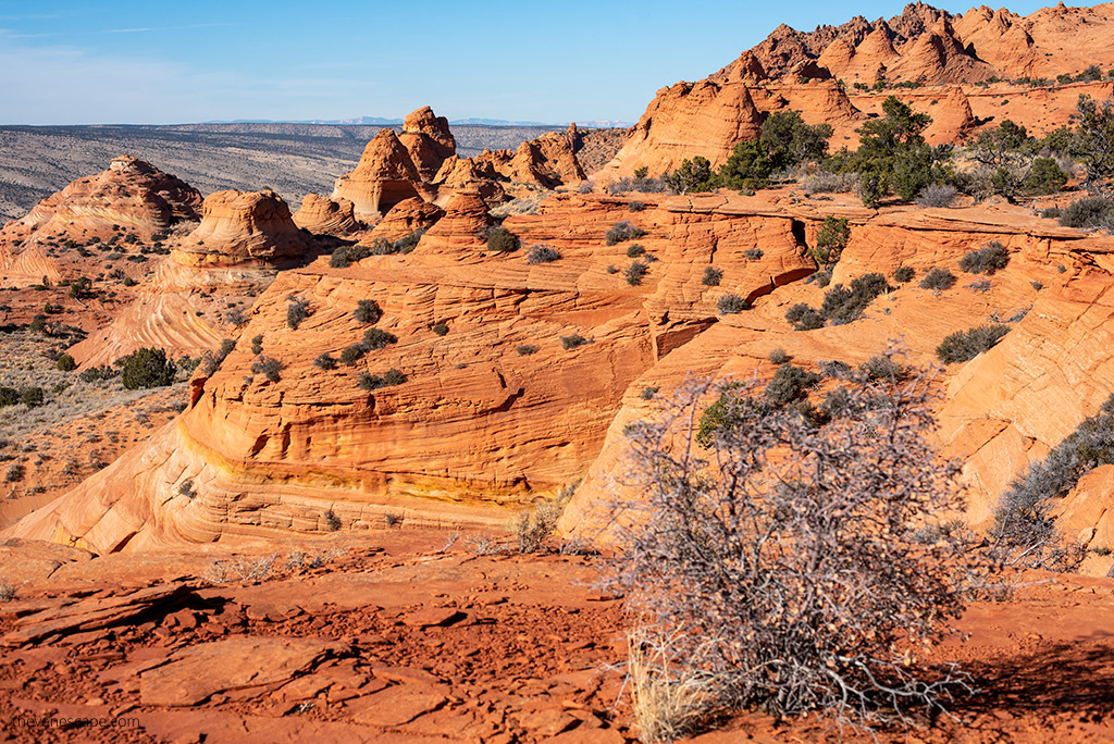
Coyote Buttes South Hike – Our Experiences
Social media have immense power. They created the Wave Arizona in Paria Canyon-Vermilion Cliffs Wilderness as the most famous rock formation on the border of Arizona and Utah. Thousands of people are trying to get the Wave permit every day. They want to take an Instagrammable photo. However, the Wave is the only small northern part of the fantastic Coyote Buttes area. Coyote Buttes South Hike is an even more delicate sandstone formation.
Coyote Buttes South is more colorful and picturesque than the Wave. Fragile windswept layers with a vivid display of colors fill the desert oasis of Coyote Buttes South, which looks like a fairytale. The area is also limited to 20 people per day because it’s such a unique world formation.
However, people often don’t know that the Coyote Buttes South exists. So, it’s worth going on the Coyote Buttes South Hike. It is a fantastic experience in the desert wilderness. Check out our tips on how to get the permit and how to prepare for this challenging hike.
When exploring the Kanab area and trying to win the Wave lottery, my partner Chris and I made this hike. It was an amazing experience, as Coyote Buttes is a less popular rock formation, but it is stunning. We share our first-hand experience, photos, and insights from this hike. It wasn’t easy to get to the trailhead, and we lost in deep sand, so check out our tips before you go there.
Coyote Buttes North vs Coyote Buttes South
Where is Coyote Buttes?
Coyote Buttes is a part of the 112,500 acres (455 km2) Paria Canyon-Vermilion Cliffs Wilderness. It is spanning south-central Utah and north-central Arizona. South of US 89 is halfway between Kanab, Utah, and Page, Arizona.
It is divided into two areas: Coyote Buttes North with world-famous the Wave, and more remote and fragile Coyote Buttes South. While Coyote Buttes itself is in Arizona, the closest place to stay is in Kanab, Utah. And BLM Kanab Visitor Center administrates this area.
Visiting Coyote Buttes North and South requires a hiking permit. It is important to know that permits are issued for 20 people per day, 10 of them online in advance (Advanced Permit) and 10 during the Daily Lottery, two days before your hike. Below, we provide details about each of the lotteries.
It is a wilderness desert area, without marked trails, administered by the federal Bureau of Land Management (BLM).
Kanab is the best and the closest place to stay for a night before the hike. Also, prices are more affordable. Check out more things to do in Kanab and Kanab area.
Coyote Buttes nearby Attractions
Coyote Buttes are just a couple of hours from the Grand Canyon South Rim and Grand Canyon North Rim, so it’s worth considering this place during your Arizona road trip.
Also, it’s very close to the Page, where you can admire the famous Horseshoe Bend and Navajo slot canyons: Upper Antelope Canyon, Lower Antelope Canyon, and Antelope Canyon X.
It’s close to the Kanab, so you can also consider a nearby hike to the Great Chamber at Cutler Point and the Zebra Slot Canyon hike.
What are Coyote Buttes?
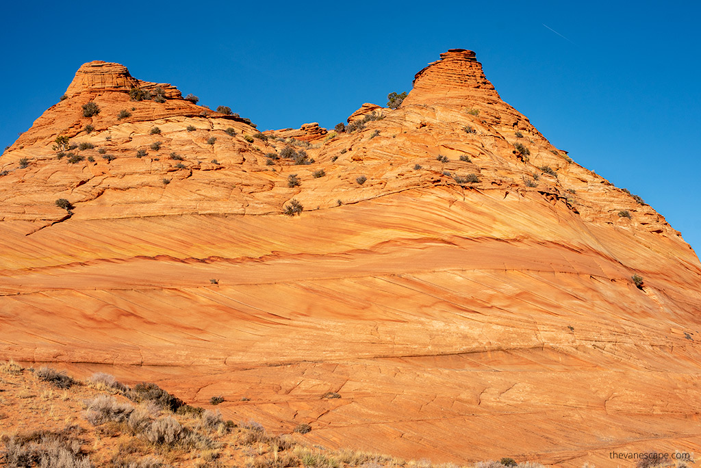
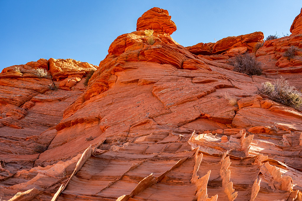
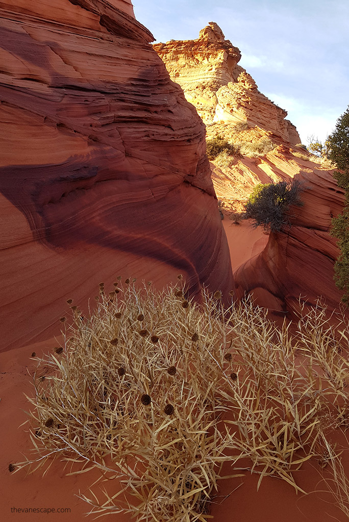
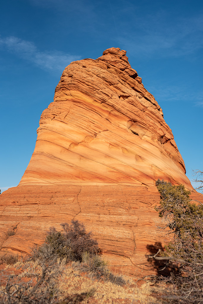
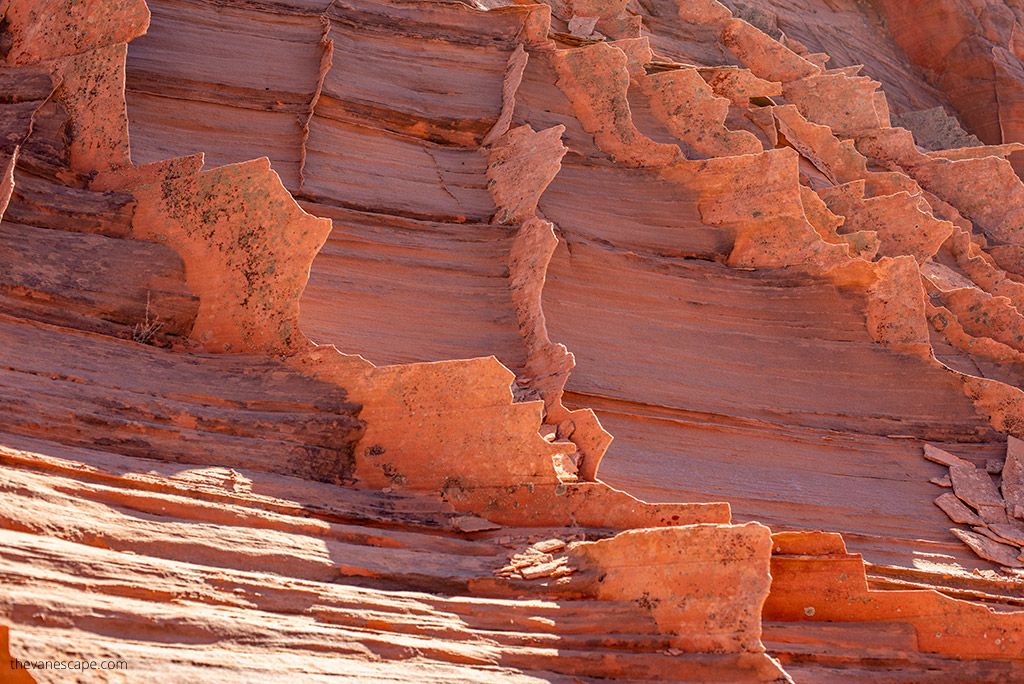
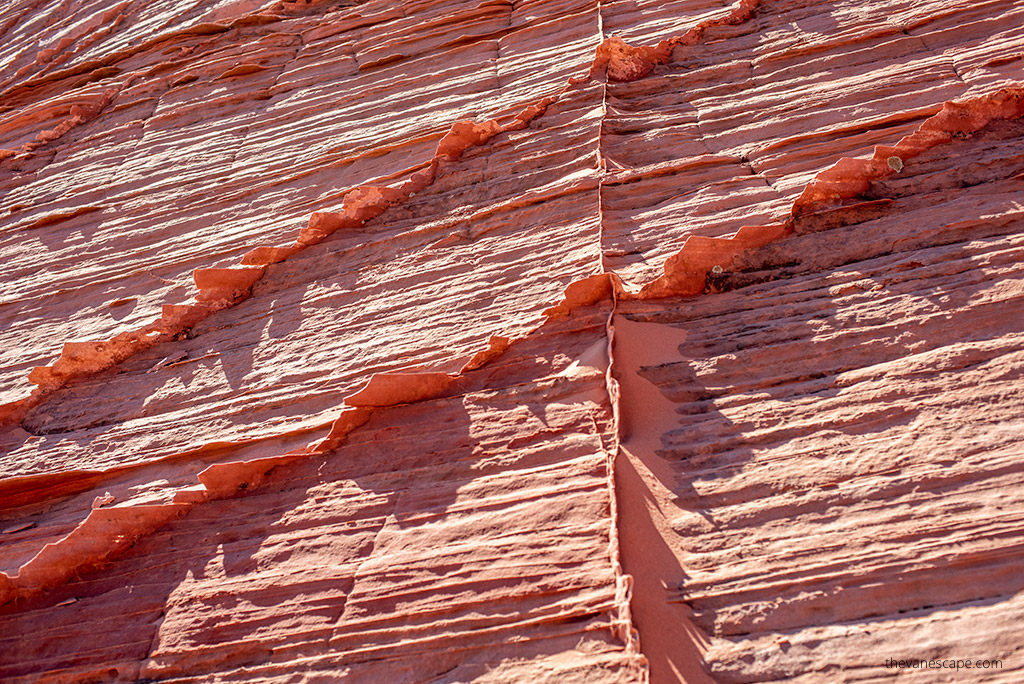
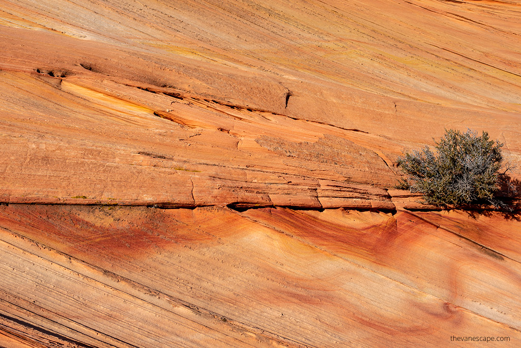
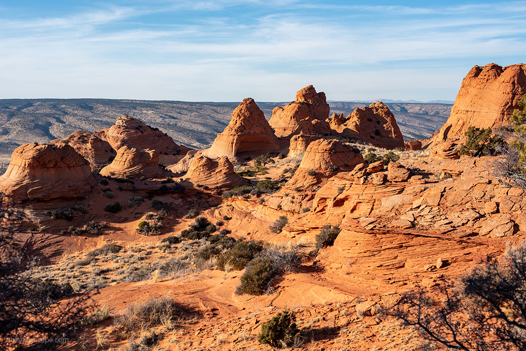
Coyote Buttes are stunning, colorful, and delicate Jurassic Navajo Sandstone formations as hoodoos, cones, ridges, and ravines. They are very photogenic and look like from another planet. The sandstones’ variable coloration is a result of various iron oxide pigments within the layers—the colors span from reds and pinks to yellows and oranges and even some green.
The Coyote Buttes area includes dramatic swirling erosional rock formations such as The Wave in the Coyote Buttes North.
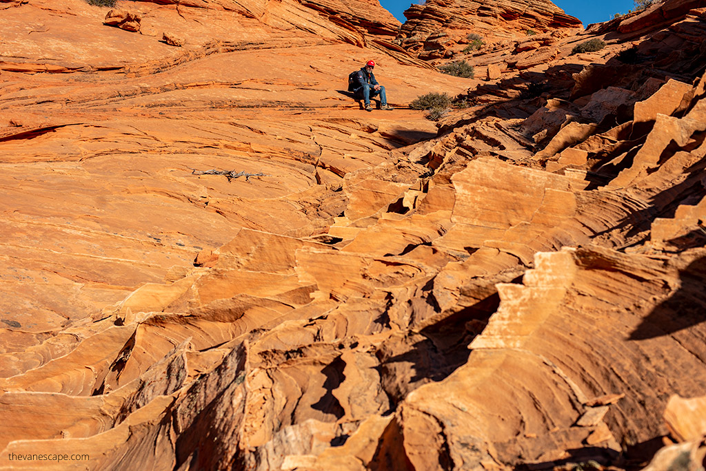
In Coyote Buttes South, erosion has created unusual and different formations and strata, some soft and fragile like glass, but some hard as a rock. This desolate land contains twisted and striated sandstone formations.
Some are as delicate as spider webs or butterfly wings, so be careful not to destroy them. All of the sandstone creations are slowly crumbling as they continuously succumb to the forces of nature.
Coyote Buttes South Parts
Coyote Buttes South offers the most pristine nature. It is such a remote wilderness area that meeting other hikers throughout the day is challenging. The Coyote Buttes South Hike is a strenuous hike because there are no marked trails, no mobile coverage, and high sun exposure in desert terrain.
Coyote Buttes South is divided into two areas, Cottonwood Cove and Paw Hole. So, you must drive (road accessible only for high clearance 4WD vehicles) to two separate entry points or hike cross-country to see both parts.
If you must choose one, go to Paw Hole. Coyote Buttes South, with its rock piles (also known as teepees), fins, and arches, is so enthralling that you don’t want to leave.
What is the difference between Coyote Buttes North and Coyote Buttes South?
On the Coyote Buttes North, there is only one primary formation, which you can see – the world-famous Wave.
South Coyote Buttes are located just south of the Wave, and it is a more variety of sandstone butte formations. South Coyote Buttes are lesser-known and harder to get. There is more variety of sandstone formations, and the views are stunning. The colorful stripes and abstract rock shapes provide infinite opportunities for taking pictures. The Wave is a shorter hike, while Coyote Buttes South is an all-day hike adventure in a remote, desolate land.
Finally, the chance of receiving a permit to Coyote Buttes South is much higher than getting a permit to the Wave. So, if you want real adventure and unique photos, Coyote Buttes South is for you.
Coyote Buttes South Permit – How to Get It?
Obtaining the permit to Coyote Buttes South is much easier than the Wave permit or a permit for the famous Havasu Falls.
There are two ways to obtain a permit for hiking to Coyote Buttes South. You can try to get an online Advanced Permit. However, if you stay in Kanab or Page during your Arizona road trip, you can enter the Daily Lottery two days ahead of the permit date.
Coyote Buttes South Daily Lottery
The Coyote Buttes South Daily Lottery is a new system. If you are in the Coyote Buttes area, the legacy walk-in lottery has transitioned to the new Daily Lottery. While within the geofence area on a mobile device, this lottery is available only by going to Recreation.gov in your browser or installing the Recreation.gov app.
Pro Tip: You must follow several steps and deadlines: submitting the application, entering the lottery, and collecting your permit. If you miss a deadline, your permit won’t be issued. Look closely at the chart under Important Deadlines for details on time zones. 4 WD is required for this hike.
Information about the Daily Lottery
- Applications must be submitted two days before your hike during the lottery application window (6 a.m. – 6 p.m.).
- You must have a mobile device to apply—desktop PCs or laptops won’t work. Out-of-date Recreation.gov apps will cause payment issues.
- You must be in the geofence area to apply (see this map at the bottom of the page)
- 10 people and/or 4 groups (whichever comes first) will receive a permit in this Daily Lottery.
Daily Lottery Schedule
- Day 1 – Application: Apply between 6 am and 6 pm, two days before the desired entry date. Lottery results are sent out at 7:15 pm that evening. The window will open to accept the lottery.
- Day 2 – Safety Briefing: Successful applicants must accept the permit and pay the fees by 8 a.m. Utah time and be at the permit pickup location at 9:00 a.m. local time for a safety briefing. Local time may be different between pick-up locations. During daylight savings time, 9:00 a.m. in Utah is 8:00 a.m. in Arizona (except in the Navajo Nation)
- Day 3 – Permit Day: Permit holders will have the day to explore Coyote Buttes South
Applications can only be submitted via a mobile device (e.g., a smartphone or tablet with an internet connection) using the Recreation.gov mobile app or browser.
Daily Lottery Fee
- Application Fee: A non-refundable lottery fee of $9.00 is required for each lottery application.
- Recreation Fee: If you’re selected in the lottery, you must pay a $5.00 recreation fee per person or dog. This fee is paid online when you enter additional information to complete the process after you win. All persons, regardless of age, must be included in the permit. This includes young children who cannot yet walk. Payment of recreation fees is only required if the permit is issued as part of the lottery.
Coyote Buttes South Advanced Permit – On-line Permit
If you are planning your visit four months in advance, you can try to win an Advanced Permit. For Coyote Buttes South, you can get online permits. Make sure to follow all official tips. Reservations are accepted at 12:00 noon (MT) on the 1st of each month for a permit during the third month ahead.
Reservations are not accepted for trips beginning day-of or the next day. For example, permits for the month of August would become available on May 1st at 12:00 noon MDT. Online reservations would not be accepted starting on August 14th for a trip on August 15th.
Applications beginning at noon (12:00 MDT) on:
- January 1 – Reservations accepted starting at 12 noon MST for a permit during April
- February 1 – for a permit during May
- March 1 – for a permit during June
- April 1 – for a permit during July
- May 1 – for a permit during August
- June 1 – for a permit during September
- July 1 – for a permit during October
- August 1 – for a permit during November
- September 1 – for a permit during December
- October 1 – for a permit during January
- November 1 – for a permit during February
- December 1 – Reservations accepted starting at 12 noon MST for a permit during March
Coyote Buttes Weather
The best seasons for the Coyote Buttes South Hike are spring, fall, and winter. There is no shade, you have to hike in deep sand, and there is no marked trail. The direct sun makes this hike extremely hot in the summer. Monsoon season can make the area very dangerous for both hikers and drivers.
Flash floods can ravage the road and the park for a reason. And they happen, so always check the weather before your hike. The best idea is to ask about weather conditions in the BLM Kanab Visitor Center.
Below, we’ve compiled charts with the lowest and highest average temperatures in Coyote Buttes South. Moreover, we have also prepared the average precipitation for each month.
Coyote Buttes South Map
The Coyote Buttes South permit is just the beginning of the adventure. You should be prepared well for this hike. Your safety is most important. There is no phone coverage. Furthermore, there are no designated trails, pure wilderness.
For your safety, it would help if you told someone, such as friends or family, who will not be on the hike when you start. If you plan this hike, you can stay the night before in Kanab (Utah) or Page (Arizona). There are two main access points for the Coyote Buttes South area: Paw Hole and Cottonwood Cove, and we prepared the map below with the main points in the area.
How to Get to the Coyote Buttes South Trailhead?
It is not easy to get to the trailhead. You must have a 4WD high-clearance vehicle. First of all, you have to reach House Rock Road. House Rock Valley Road runs north/south between Highway 89 in Utah and Highway 89A in Arizona. House Rock Valley Road is renamed House Rock Road once you cross the Arizona state line, so you’ll see the road referred to with both names.
From Kanab and Page
From Kanab, Utah, drive 40 miles east on US-89. Turn right onto House Rock Road, a dirt road located between mile markers 25 and 26. You must turn just before a road guardrail and a sweeping left-hand curve. Next, you must drive for 17 miles.
You will travel past the Wire Pass parking lot at 8.3 miles and then the Utah – Arizona state line. When you near 17 miles, look for an unmarked turn-off on the left side of the road. There is small parking at Lone Tree before the turn-off. Parking for the Paw Hole Trailhead is 2.5 miles from the turn-off.
If you are going from Page, Arizona, the distance is similar.
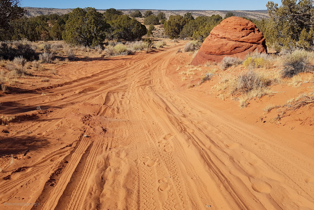
To reach the South Coyote Buttes trailheads, a 4WD high-clearance vehicle is required. However, even with a 4WD, the main road is impassable and dangerously slippery if wet due to the clay content. The road is also challenging to get to, so drive carefully.
Moreover, if you don’t have experience driving in sharp rocks and deep sand, consider leaving your car earlier at the Lone Tree reservoir parking lot. Then, you have to walk through deep sand for around 2.5 miles to get to the Paw Hole trailhead. So, start your adventure early in the morning.
Because we had a camper truck, a heavy vehicle, even though we had a 4-wheel drive, we left our car in the Lone Tree parking lot before the turn-off. Then, we walked 2.5 miles in the sand to the Paw Hole trailhead. Our car was heavy, but we saw a regular pickup stuck in deep sand on the road.
So, pack appropriate tools to deal with flat tires or car issues on the road.
But if you have only a 2WD vehicle or are not sure if you can drive this rough road, leave your car at Lone Tree and hike 2.5 miles.
Coyote Buttes South Hike
How Looks Coyote Buttes South Hike?
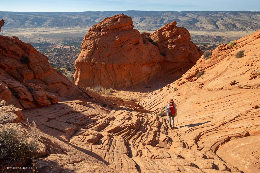
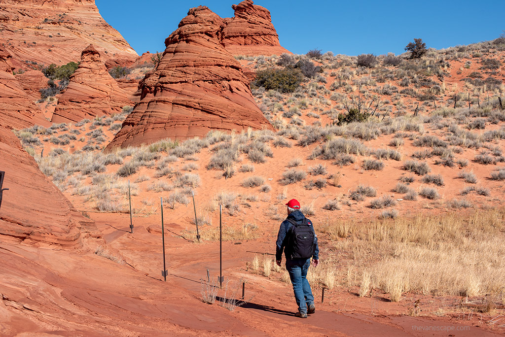
For us, it is one of the best hikes in Arizona. Coyote Buttes South Hike is a strenuous hike because there are no marked trails, no mobile coverage, and is high sun exposure in desert terrain. Moreover, there is a high probability that you won’t meet other hikers throughout the day.
You have endless possibilities for taking beautiful photos. The fantastic rock formations are unique and incredibly gentle, so watch every step to avoid damaging them. Before you go, check our hiking tips and packing list below.
First, take at least a gallon (3.7 liters) of water per person for your hike. In the summer, the temperature can often be well over 100 degrees.
OUR TIP: Start hydrating yourself a day or two before the trek, drinking a minimum of 0,5-0,6 of a gallon (2-2,5 liters) of water daily. There isn’t any water available on the trail, so plan to hike in the coldest part of the day, and start it early in the morning.
Paw Hole
When you get to Paw Hole, you start your hike from the parking area. Look for the small arch at the top of the first hoodoo. There are no marked trails. This route is more of an exploration around the rocks. However, do not climb to the fragile rock and watch your step. You will see a small fence from the parking area, go through it, heading for the buttes.
You will see dunes and a beautiful sandstone bowl at the end of the dunes all around you. Hike around the bowl and along the sand toward the hoodoos to the northeast. Once you turn west and top out on the ridge, House Rock Road appears to the west. You will see a variety of oddly shaped, fragile rock formations. You will find plenty of photo opportunities there. Just use your creativity. You have to hike in deep sand and sharp but breakable rock.
Other posts about Arizona with tons of tips and exciting information you will find in our Arizona PhotoTravel Guide!
Cottonwood Cove
If you want to get to Cottonwood Cove, you have two options. You can walk there from the Paw Hole hike or back to the parking and drive to the Cottonwood Teepee parking area. You need to turn north or left, just before the windmill and other dilapidated structures.
Travel north through the gate into the South Coyote Buttes Special Permit Area. Leave any barriers behind you. The road becomes impassable, and you will find a parking area. Both north and west from the parking area are massive hoodoos called the Cottonwood Teepees. You can hike over the desert sand to the rock formations.
What is Coyote Buttes South Hike Elevation?
South Coyote Buttes Elevation is 5789 feet.
The top of Cottonwood Teepees Elevation is 5933 feet.
Paw Hole Starting Elevation is 5950 feet.
Paw Hole Highest Elevation is 6350 feet.
Hiking Tips For the Coyote Buttes South
First of all, there is little or no shade, and sand reflects the sun, amplifying the effects of heat. So, carry with you plenty of water in a water reservoir and salty snacks, no matter when you hike. You need at least one gallon of water per person because no water sources exist. We were doing this hike at the end of November, and it was hot. There were over 78 degrees Fahrenheit.
The hike was amazing. The land is a desert wilderness, so you can also choose to climb around on your own. However, it’s easy to get lost, so a topographic map and GPS watch or handheld are a must-have.
Below are our hiking tips and essential packing list for this hike.
Balance Water and Food
Drink lots of water the day before your hike. Because if you wait until you are thirsty in the desert, you will already be dehydrated. Drink when you are thirsty and stop when you are quenched. Snacks are also important during your hike. Because over-hydration can lead to hyponatremia. So, balance water and food during your hike.
Take Care of Your Body
Watch your body while hiking. Even experienced hikers have weaker days. If you start to feel dizzy, disoriented, or nauseated, take a rest. Drink and eat a salty, high-protein snack, and rest as long as you feel better.
If you are cold, put on extra layers and eat.
If you are hot, drink more water and rest. Protect your body from the sun. Take a sun hat and sunscreen. It’s best to have long sleeves and pants to protect your body against the sun and sand. Moreover, clothes should be airy and quick-drying.
Knows the Signs of Hyponatremia, Hypothermia, and Heat Illness
Signs of Heat Illness
Heat illness is a spectrum of disorders due to environmental exposure human body to heat. It includes minor conditions such as heat cramps, heat syncope, heat exhaustion, and the more severe disease known as heat stroke. Signs of heat illness are headaches, dizziness, vomiting and nausea, cramping, and decreased urine output.
Remember that hydration is most important during your hike, so start drinking water the day before the hike. Moreover, take a lot of water, but balance it with high-energy foods, such as high-protein bars or beef jerky. Rest in the shade, and remember to protect your head and body from the sun.
Signs of Hyponatremia
Hyponatremia is a low sodium concentration in the blood. It is caused by overhydration. So you should always balance hydration with salty and high-protein snacks and meals, electrolytes, or protein bars, and rest frequently.
Mild symptoms include a decreased ability to think, headaches, nausea and vomiting, difficulty walking, and poor balance. Severe symptoms include confusion, seizures, and even coma.
Signs of Hypothermia
Hypothermia is defined as a body core temperature below 35.0 °C (95.0 °F) in humans. Symptoms depend on the temperature. Hypothermia is a condition in which heat is lost faster than the body can produce it.
It occurs when someone is exposed to external factors that lower body temperature for a long time, e.g., ice, water, or cold. Signs of hypothermia: uncontrolled shivering, exhaustion, and confusion.
The best idea is to take extra dry clothes, like thermal underwear, and put on dry clothing. Drink water and liquids, and protect yourself from cold, wind, rain, or snow using warm clothes (such as waterproof layers and a warm hoodie) and an emergency shelter or emergency sleeping bag.
You will need them if you lose your directions and will have to stay for a night in the desert wilderness. Remember that it immediately gets dark and cold in the desert after sunset, and temperature differences can be up to 30 degrees and more.
I didn’t know that the wave was part of Coyote Buttes North! You learn something new everyday! I’m a huge fan of rock formations like the ones found in the Coyote Buttes. I’m definitely going to have to check them out! Thanks for the comparison of either side, this will help tremendously in planning the trip!
All I can say is wow! What formations. I have not heard of Coyote Buttes North or South but can now understand why it is so popular. The way they handle the visits with permits booked in advance is such a great idea. Thanks for the tips as well on hiking, best time to go and health etc they are very handy.
I’ve
not visited this part of the country when in the US, and what a mistake! A hike
at Coyote Buttes would be incredible, not to mention the photo opportunities. It’s good to know the information about the permits; I would have attempted to visit without one. I’d also love to catch that wave, it’s mesmerising!
This is my first time hearing about Coyote Buttes and I can say that is truly fascinating. No wonder a lot of people are keen to visit. Thank you for sharing this and tips regarding the permit. Will consider this over the North. 🙂
It actually sounds like you get more of an experience out of Coyote Buttes South than you do the wave! I’m sure the wave is fantastic, but the fact that there are only 20 permits issused a day probably adds to its “hype.” Ugh, I don’t know if social media has done more harm or good for places like the wave. It’s a shame that people who actually want to see it might not be able to as there are people seeking the permit just to get a good selfie. Not sure how to feel about that.
Great post!! I am appalled that I haven’t been to Coyote buttes or even heard about it before, the place looks amazing and it seems like it got some great trail for hikes. I am definitely adding this place to my list. Great information on permit I had no idea that you have to apply the permit 2 months prior to the trip.
Coyote Buttes Hike is absolutely a trekkers heaven. I don’t even know what I chose first – the south route or the north route. I would love to hike both pf them, especially after studying that useful graphs you have provided for weather. I am used to hiking, so I have a lot of technical gear but what I would like to have the most is a tent and the possibility to sleep there, in the middle of the nature.
I had never heard of Coyote Buttes before, but I must say that they are simply amazing. It was good to know about the restriction on the number of visitors. In this was the place remains pristine. The place looks really fascinating and the photographs are totally amazing. I would love to go for trekking in both the routes – north and south.
I am bookmarking this post. This is the ultimate guide for Coyote Buttes South. Such a detailed one. Loved reading about the tips. The photos are breathtaking. Though I am a moderate trekker. But still I would like to see this nature’s wonder in my naked eyes. Absolutely stunning. Thanks a lot for a perfect guide.
I just looked and it’s 6 hours from where we live in Arizona. At 72, I don’t think I can do this anymore. Thank you very much for giving me a glimpse of Coyote Buttes South!
Wow – these rock formations are amazing – I would so love hiking there. The name, however, irritates me – Coyote buttes sounds a bit like the coyote’s butt….I know, I’m simply immature.
The landscapes look stunning. Starting from driving to the trail head, the whole hike sounds like a great adventure! I hope the influx of social media driven tourists at the ‘wave’ does not impact the uniqueness of the overall place or the hike.
Your point of view caught my eye and was very interesting. Thanks. I have a question for you.
Your article helped me a lot, is there any more related content? Thanks!