The Subway Zion Hiking Guide
The Subway hike in Zion National Park is a fantastic adventure. It’s one of the best hikes in the park. But it’s not an easy trek; it is a backcountry, off-trail route. You will need a Zion wilderness permit and prepare yourself a little bit because it’s a long, 9-mile round trip in rough terrain. Most of this time, you will walk in the cold stream, crossing it from one riverbank to another. How to get a Subway permit? How to prepare for The Subway Zion Hike? What gear to take? We share our experiences in this detailed Subway Zion Hiking Guide.
This article may contain affiliate / compensated links. For full information, please see our disclaimer here.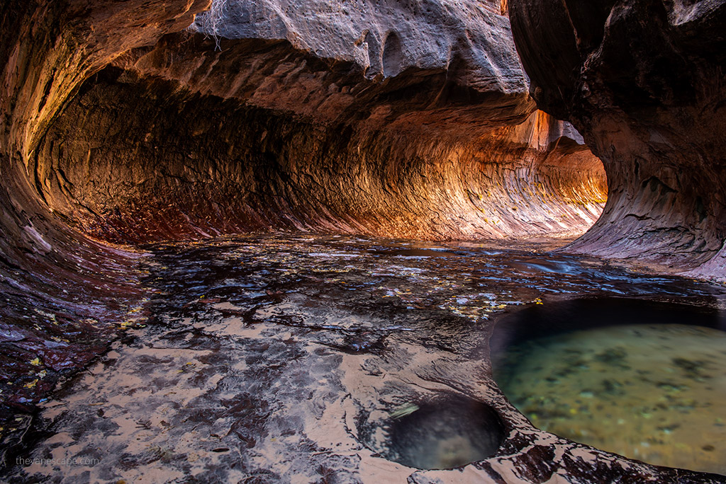
What is The Subway in Zion?
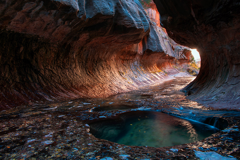
The Subway is a small, uniquely shaped tube-like tunnel slot canyon within the Zion Wilderness in Zion National Park in Utah.
It’s a short canyon of fewer than 0.25 miles (0.40 km), but it is stunning. The Left Fork North Creek flows through The Subway and the Great West Canyon. This article describes The Subway Zion Bottom-Up hiking route (known as Left Fork), which is perfect for all photography-passionate and experienced hikers.
We love this hike. My partner Chris and I have done it twice so far, and we share our experiences, insights, and photos from this adventure. It’s a backcountry adventure through remote terrain. It requires navigation skills and a long hike out. We give you a lot of tips on how to prepare for it.
But if you are looking for another best hike in Zion, lodging recommendations in Zion, or advice on preparing for your trip to Zion National Park, check out our article about Zion National Park.
The best place to stay overnight before the Subway hike is in Springdale, one of the best adventurous towns in Southern Utah. Book your accommodation in advance.
Preparing for a hike to Subway is most noteworthy. So, check our list of 13 essentials of any hike before you hit this trail. Also, make sure to check out our detailed Day Hiking Packing List to prepare for this adventure.
PRO TIP: Are you planning the Utah road trip? Check out our detailed Utah National Parks itinerary!
The Subway Zion Bottom-Up Hike Basic Info & Map
Level/Rating of the Subway Hike
It is a strenuous all-day hike, 9 miles out and back, that starts by descending a steep slope to the bottom of the Canyon. The terrain is tough, and there is no marked trail. The Subway hike includes a trek in a cold river that is crossed many times. The water is full of slippery rocks, trees, and other obstacles.
It’s tricky to navigate sections of wet rock formations from one riverside to another riverside alternately.
So you need a day to do this hike and start early in the morning. Also, be prepared to get wet. Most of all, do not do this canyon if there is a threat of rain.
Is a Permit Required for the hike to the Subway?
Yes, the Subway Zion Hikes requires a wilderness permit. All hikes through the Left Fork/Subway require a permit. Detailed info is below.
Elevation Gain in Subway Hike
It is a steep 400-foot descent from the trailhead to the bottom of the canyon.
Hiking Distance – Time Required & Length of the Subway hike
You should have at least 7-10 hours. The hike is 9.0 miles round-way, but it’s strenuous, and there is no marked trail. Start it early because it’s a challenging trail, and losing the path is easy.
The Subway Hike – Trailhead Location
Left Fork Trailhead is roughly 8.2 miles up the Kolob Terrace Road from the town of Virgin. Mileage Driving time from Springdale is 45 minutes.
The best seasons for hiking the Subway in Zion
What is the best time to hike the Subway Zion? From late spring through fall, although spring runoff in April and May might make hiking much more difficult, even dangerous. So, ask about current conditions at the Wilderness Desk in the Visitor Centre in Zion.
The best colors are during autumn, so we highly recommend October – November for the Subway hike. The trek is also possible in winter, but you need a drysuit/wetsuit or other adequate icy water protection. So, check our gear recommendations below. The most important is your safety. First of all, check the weather, the flow rate, the water level, and the flash flood potential before you go.
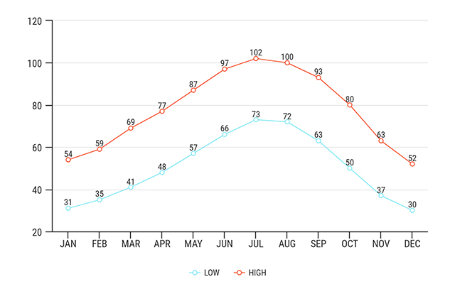
Average temperatures in Zion
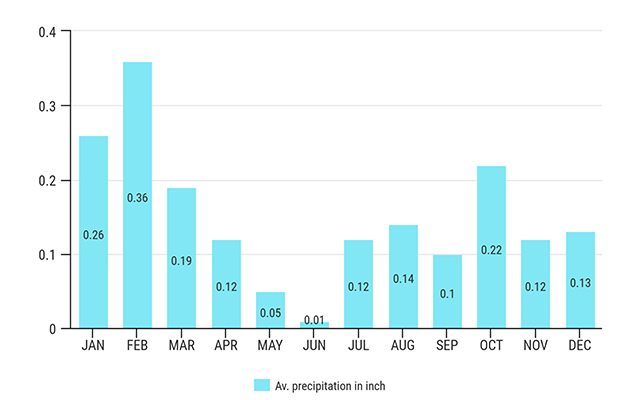
Average precipitation in inch
The Subway Zion Trail Features
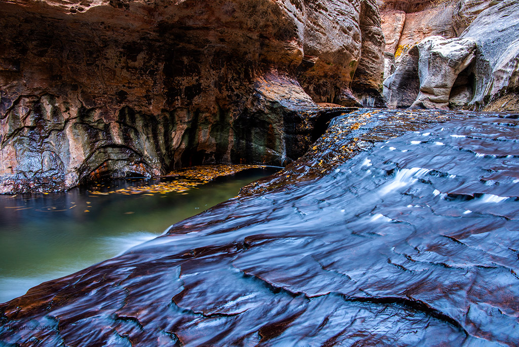
The Subway is unique, like an underground tunnel rock formation. The trek offers spectacular views of the Canyon through the river; it’s breathtaking wilderness, one of the best in Zion National Park. Most of all, the hike provides plenty of opportunities for photography.
Options & Permits for Hiking The Subway
The Subway has two ways to explore. Permits are obligatory for both of them. Both treks involve extensive route finding; there is no marked trail. The Subway is a one-day hike only.
Overnight is prohibited, so the best idea is to start the Subway hike just after sunrise. Both trailheads are located on Kolob Terrace Road.
Hiking the Subway from the Bottom Up (Hiking Route)
It is a strenuous 9-mile round-trip hike through the Left Fork of North Creek that requires route finding, creek crossing, and scrambling over boulders. This hike begins and ends at the Left Fork Trailhead on Kolob Terrace Road. In this article, we focus on and share our experience on this hike because we made it twice.
Hiking the Subway from the Top Down (Canyoneering Route)
It is a strenuous, semi-technical 9.5-mile trek that requires rappelling skills, 60 feet of rope, and extensive route-finding experience. The route also requires swimming through several deep pools of icy, debris-filled water. The trail begins at the Wildcat Canyon Trailhead and ends at the Left Fork Trailhead.
We didn’t make this trail, as we are photographers, and our goal was to take great pictures of the Subway. So, if you need more info, you can check it on this canyoneering website.
Permit for The Subway Hike – online application
Due to the popularity of the Subway hike in Utah, the NPS created an online lottery for reservations. You will find detailed information on the NPS website. The number of permits is limited to 80 people a day only. Hiking The Wave Formation is another exciting place in the area for which you need a permit.
The Seasonal Lottery for Subway Hike: 4 Months in Advance
An online Seasonal Lottery is held for all trips, all year, into the Left Fork of North Creek (Subway) to obtain a reservation for a Wilderness permit. Seasonal Lottery applications are completed online.
Your entries have to be submitted 4 months before your planned trip. So, for a trip in April, May, or June, you must participate in the lottery between February 1 and February 25. If you plan your trip in July, August, or September, you must participate in the lottery between May 1 – May 25. For the Subway hike in October, November, or December, you must participate in a lottery between August 1 and August 25.
The non-refundable lottery application is $6.00. Applicants will receive a notification email on the fifth day of the following month with information about the status of their request. You can apply here. You’ll have to pick up the permit in the park the day before your hike, so plan it. If you win the permit, the fee is $10 per person.
The Daily Lottery for Subway Hike: 2 Days in Advance
The daily lottery for the Subway hike in Zion National Park operates online and is for obtaining a Wilderness permit. You can apply on this website two days before your intended hike date between 12:00 am and 3:00 pm MT.
The lottery draw happens at 3:00 pm MT, and applicants are notified by 4:00 pm MT of the same day. There’s a $6 non-refundable fee for each application. This lottery is an option when Seasonal Lottery or Calendar Reservations are fully booked. Permits not claimed through the Daily or Seasonal Lottery are available as Walk-in Permits.
PRO TIP: If you fail the Subway lottery, we recommend The Narrows hike Bottom-Up, which is also perfect, and you don’t need the permit.
The Subway Zion Hiking Guide – Detailed Description
Start of The Subway Zion Hike
Start your hike early, just after sunrise. Trailhead is located on Kolob Terrace Road outside of the Zion National Park limits. The Left Fork Trailhead is several hundred feet above the Left Fork of North Creek. Follow the around 0.5-mile well-maintained path from the parking lot as it heads northeast. It’s the easiest part. After that, you will reach the cliffs.
You must go down tough and steep 400 feet without a marked trail. But the path is still visible. The descent is zigzagging down into the woods. Take great care to stay on the track as it descends steeply to the canyon floor. The trail is steep and loose. Take hiking poles and hiking boots with great traction [please, read our article on choosing and using hiking poles].
At The Canyon Bottom
This way, you reach the streambed of the Left Fork. First, look back at where you came down from. Watch carefully for all signs and remember exactly where the trail meets the water. You will be tired on the way back, and it will be late.
So, it might be challenging to recognize where you should start climbing up. Like many hikers, we also passed the exit sign and lost the path. We didn’t have a GPS back then. So, it was very hard climbing in the dark.
PRO TIP: When you get down, remember this place carefully. It’s easy to miss it on the way back. Mark this point on the GPS or GPS watch. It’s great to take it on this hike.
After orienting yourself where you will start your exit, you can hike through the canyon. You have to cross the stream and turn left. It is an off-trail route, so there is no official trail. However, there are well-established social trials.
So, if you are careful and watchful, you will notice the path along the banks. Be prepared for the wet because you will have to do some significant hiking in the stream itself. If you don’t like being wet, consider if this trail is for you.
The Red Waterfalls
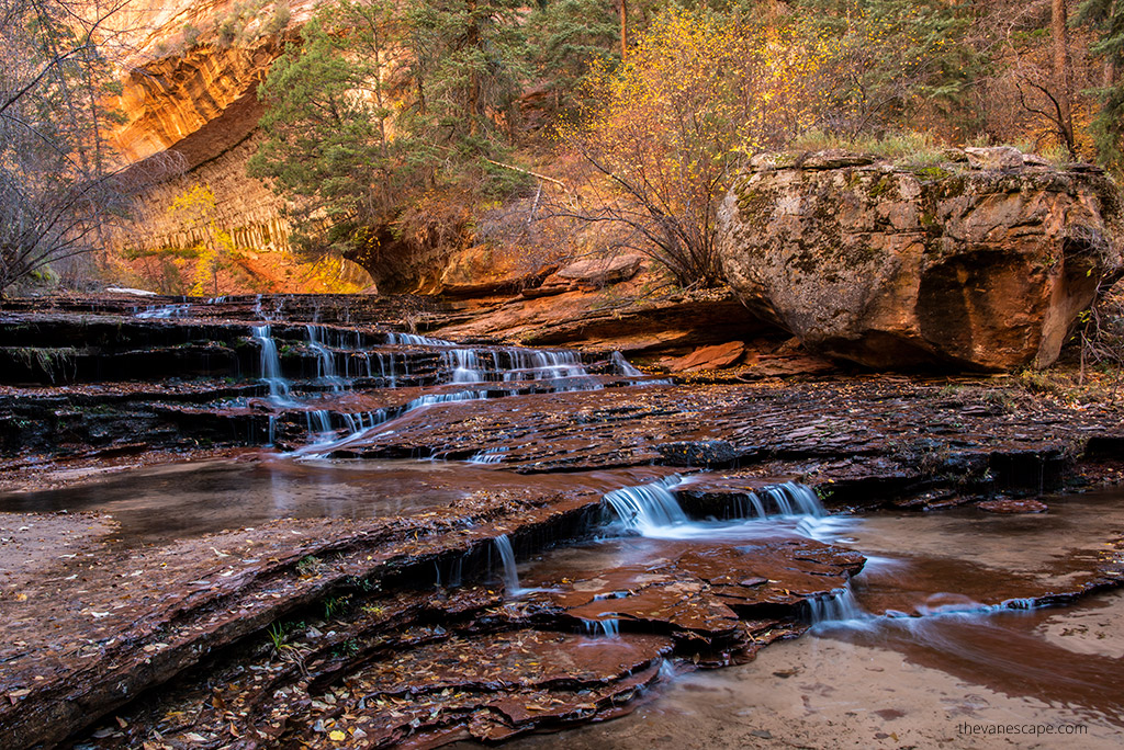
After two miles of hiking, the scenery starts to be stunning, but most of all, you have to watch out for your step; it’s very slippery. There will be several cascades on your way, and you will get to 15-foot tall waterfalls. It’s an excellent photography spot.
These cascades look like a grand staircase leading up to a mystery fairytale because the stream flows down dark red Kayenta sandstone slabs. But most of all, take great care as the rocks are incredibly slippery. Travel becomes slower and more difficult.
I (Agnes) was focused on the photos and slipped on the rocks in the stream. I decided to protect my camera, so I sprained her finger. So check our packing list for this hike to avoid an accident and prepare for an emergency.
Fortunately, we had a well-equipped first aid kit and extra dry clothes, so it was a hike with a happy end. Remember to pack properly, and don’t forget your travel insurance. It is essential.
The Subway
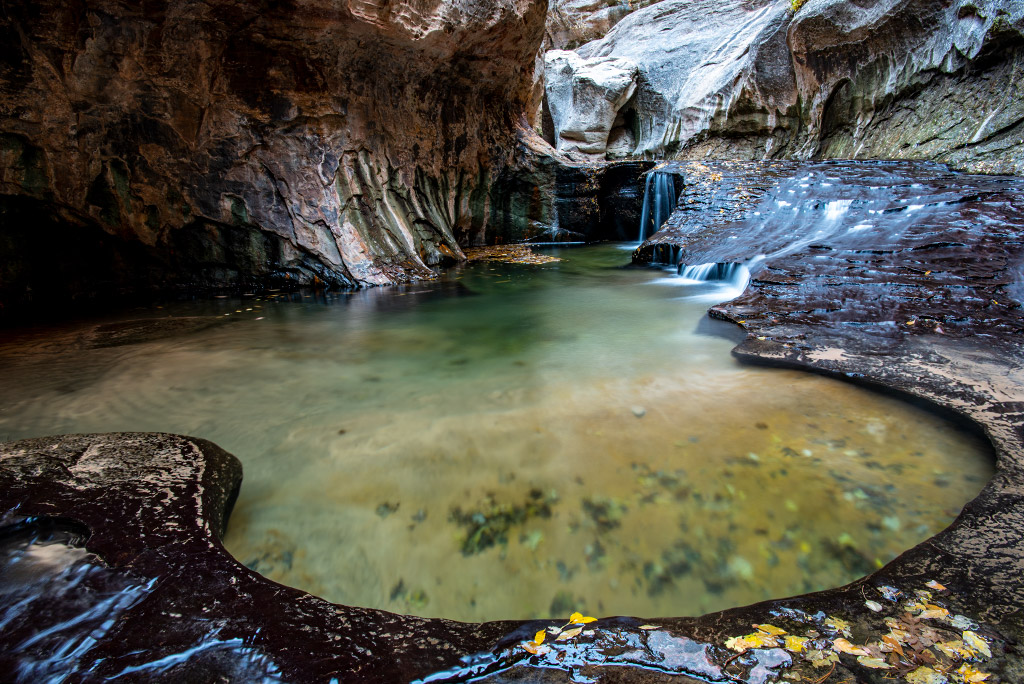
You must hike up the slabs, then turn the corner. Upstream from the second waterfall, look for the narrow crack through which most water flows. The canyon turns to the south (right), and you will see the lower Subway, a short section of the canyon where both walls come together very close, and the flowing water has cut out a larger tubular oval. It’s a spectacular view.
It looks like a railway tunnel, and you wonder when the train enters the station. It is the perfect spot to take Subway photos. The water in the pools is emerald in color, with light, warm walls, and shines on the tunnel. Ponds and waterfalls are of marvelous beauty. But watch your steps here. The rock can be very slippery.
The lower Subway is the turnaround spot for this hike. However, you can go to the pools to what’s known as the “waterfall room” to see a small 20-foot-tall waterfall. Depending on the conditions, the water may be almost waist-deep, so be prepared to get wet. Hiking poles are very useful in this wet and slippery area.
Return from the Subway
After taking photos and eating lunch, it’s time to go back. You come back the same way. But save energy for the strenuous hike uphill to return to the car. Remember that the way is long, and you will be tired, so give yourself enough time to do this.
The steep 400-foot ascent back up might be exhausting. Hiking poles will be handy. After sunset, it gets dark in the canyon immediately. The hike might be dangerous in the dark, so take a good headlamp and do not miss the exit point. With a good GPS, it will be easier.
The Subway Zion Gear Recommendations
Most noteworthy is to prepare for this hike. So, check our list of 13 essentials of any hike. But, on this trek, you will spend a lot of time in the water. So, below, you will find a list of the essential water equipment you need for the Subway hike, as well as the best water shoes for hiking.
However, we recommend this gear if you are hiking during Spring when the water level is high and it’s cold and during winter (from late November) when the water is icy. Certainly, you can rent this gear from the Zion Outfitter in Springdale.
However, if you want to spend more than one day in the water, or you consider The Narrows hike or other slot canyons, where the water level might be higher, or you like water activities, it’s worth having your own gear.
The water is warmer during summer or fall. In our opinion, hiking sandals with excellent traction and a covered toe should be enough for walking in the water in summer. Another option is water wetsuit boots, which should be perfect, too.
However, we recommend hiking boots for the climb up and down. It’s very steep and involves losing terrain, and water boots are not right and safe for it. Trekking poles will be of great help during this hike. They help you avoid slipping and falling in the water.
Neoprene water socks are also a must-have for hiking in the water. And it’s better to have your pair than rent one. They should be 4-5 mm if the water temperature is moderate, but if the water is cold, consider a warmer, such as 7 mm.
For a day hike, consider a 35-l waterproof backpack to stow your gear, such as maps, a headlamp, food, extra clothes, and other items.
The Subway Zion Photography Hints & Gear
As we mentioned before, the best idea for the trek is late fall. The colors are stunning, and the stream level is safe for people and your photo gear. The best and most light in the Subway tube is around noon and early afternoon. So be in the Subway tunnel around 11 am to start your photos; it takes you around an hour or two to take pictures.
Remember, you have a long way back. A tripod is essential for this hike. The canyon is dark, so your shutter speeds may be several seconds long. Furthermore, the water in your photos will look much more natural with a slow shutter speed.
Pack minimally for this hike. We suggest taking only one lens, a wide-angle. With this lens, you will shoot great photos of Subway.
The trick is that you need to use a longer exposure to make the water stand still and look beautiful in the picture (please compare photographs from this article). It’s best to use your Tv, S, or M mode (time pre-selection mode or full manual mode) to get this effect.
In this mode, you can set your shutter speed to 1/8s-2s. To find proper exposure settings, you must take a couple of pictures, observe the desired effect, and adjust your settings accordingly. Check out our travel gear recommendations.
- A tripod for this hike is crucial. Canyon is dark, so your shutter speeds may be several seconds long. Furthermore, the water in your photos will look much more natural with a slow shutter speed. But, most of all, you need a reliable and heavy tripod. The stream current might be strong; during spring, it is intense. As a result, water can snatch a weak and unstable tripod and destroy your camera. We have used Sirui for years, and it’s a high-quality and reliable tripod.
- Take remote shutter release, too. A remote shutter release allows you to control the shutter through a remote control, which ensures you won’t have to touch your camera. As a result, you will eliminate any unwanted blur on your subject.
- Use the polarizer filter to reduce reflections on the water and other surfaces. Some filters may warm up your scene a little bit. It will help to produce that silky water effect. So, we recommend a Circular polarizing filter, ND grad filters (minimum Lee soft edge 0.9, Lee reverse ND grad and a holder), and full ND (Lee Big Stopper or Little Stopper).
- Use a dry bag to protect your gear against getting wet.
