15 Best Things To Do In Black Canyon of the Gunnison National Park
This list of the 15 best things to do in Black Canyon of the Gunnison National Park will inspire you to a fabulous adventure. How to visit the Black Canyon of the Gunnison National Park in Colorado? How to prepare for a trip? What are the best hikes in the Black Canyon of the Gunnison? How to get there? Where to stay? How is the weather in Black Canyon? You will find answers and much more in our Ultimate Guide with Things To Do In Black Canyon of the Gunnison.
This article may contain affiliate / compensated links. For full information, please see our disclaimer here.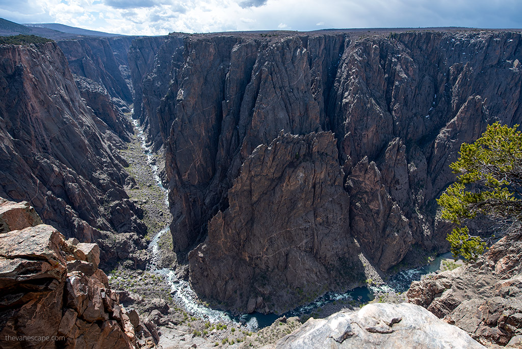
15 Best Things To Do In Black Canyon of the Gunnison – Introduction
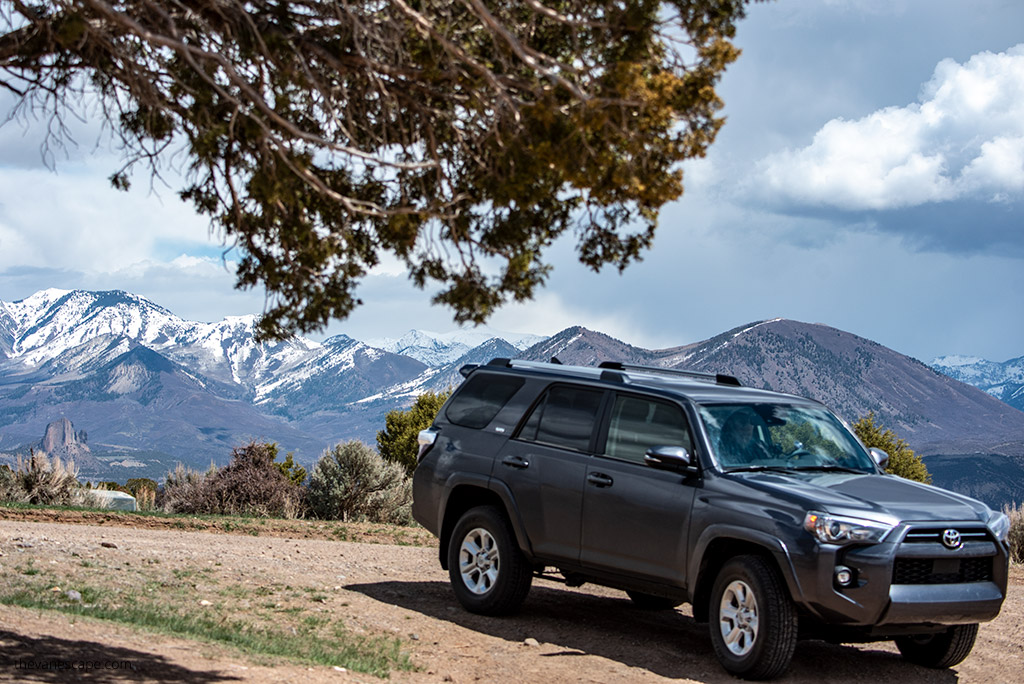
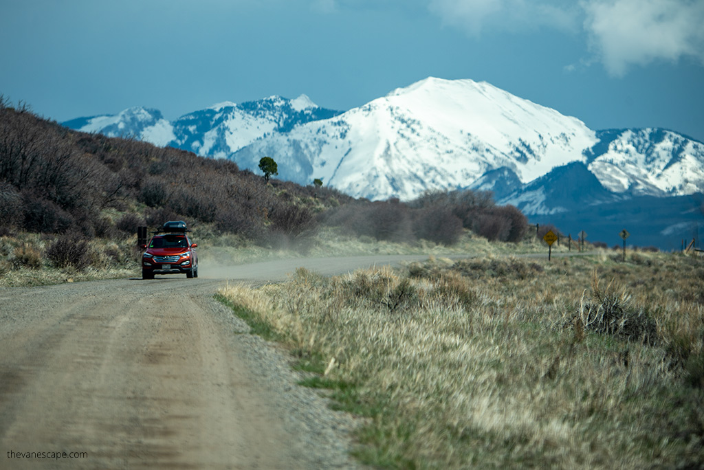
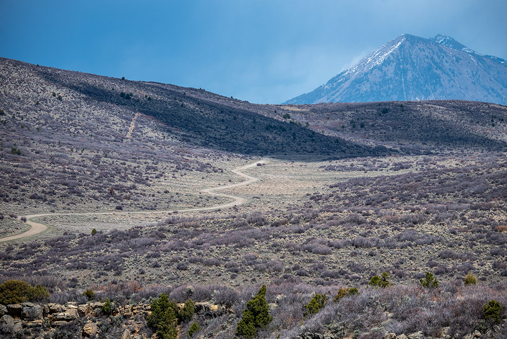
Black Canyon of the Gunnison National Park is a slightly underrated national park and the least visited in Colorado. What’s more, many people have not heard of the existence of this geologically unusual place. It’s a shame because the views are spectacular. So, make sure to add this park to your Colorado road trip itinerary.
Chris and I spent a few days in this park, knowing we would return to it. We share with you the best attractions in the park. Choose what suits your interests from our list of the 15 best things to do in Black Canyon of the Gunnison National Park. We also advise how best to plan a trip around this park and we present pictures which we took during this trip.
Facts About Black Canyon of the Gunnison National Park
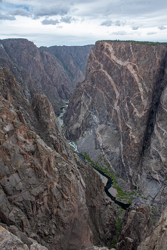
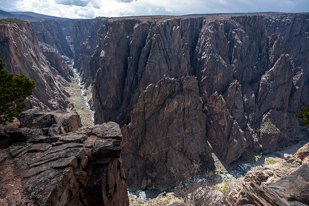
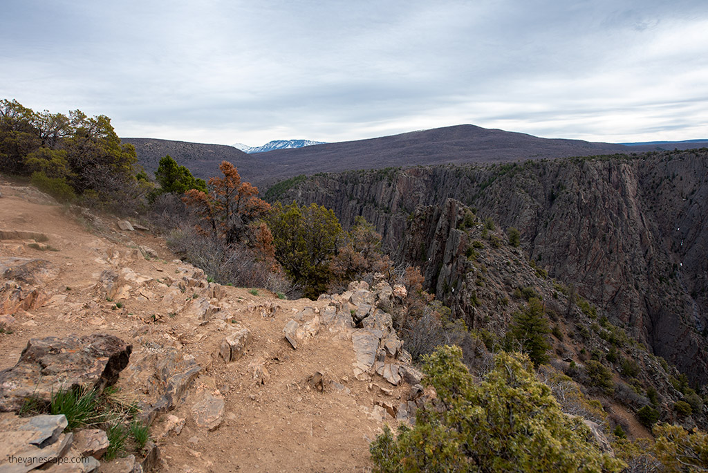
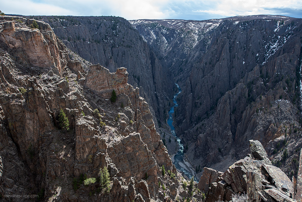
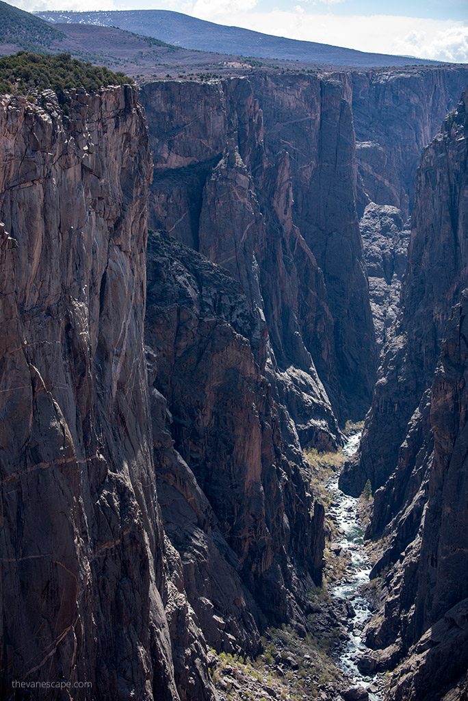
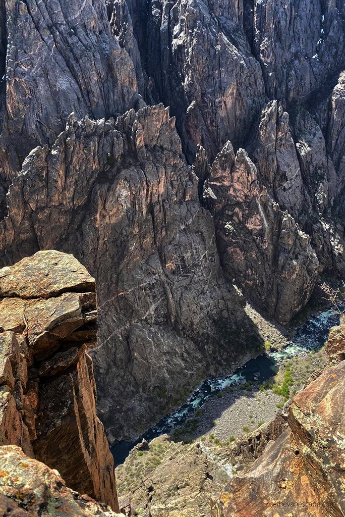
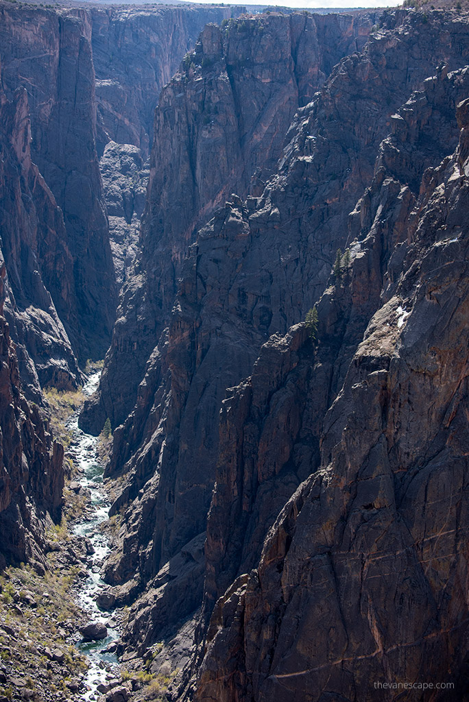
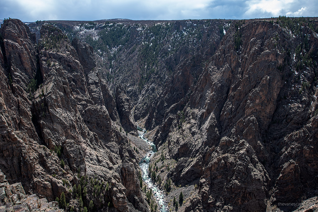
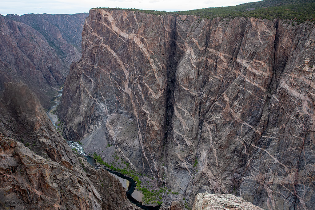
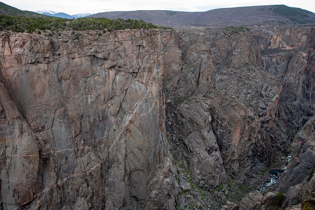
Black Canyon of the Gunnison National Park is located in western Colorado. It was established as a national park in 1999. The Black Canyon National Park contains one of the most dramatic canyons in the country, with sheer walls of gray stone rising more than 2,700 feet above the swift and turbulent Gunnison River. It took two million years to carve out the canyon. The canyon’s rim is 8,000 feet above sea level.
The size
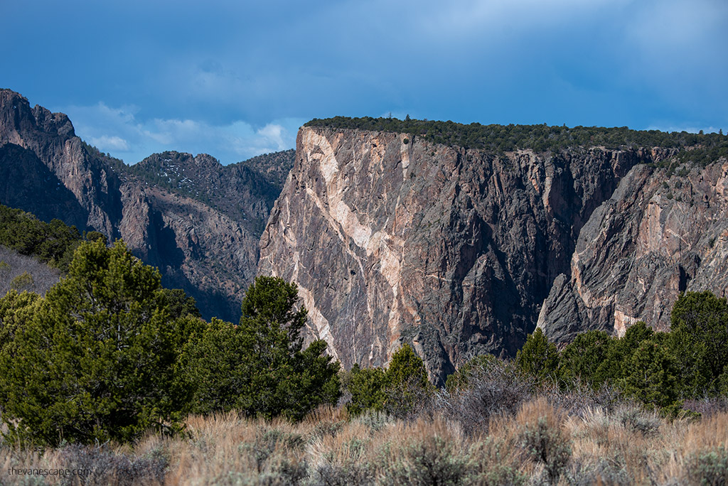
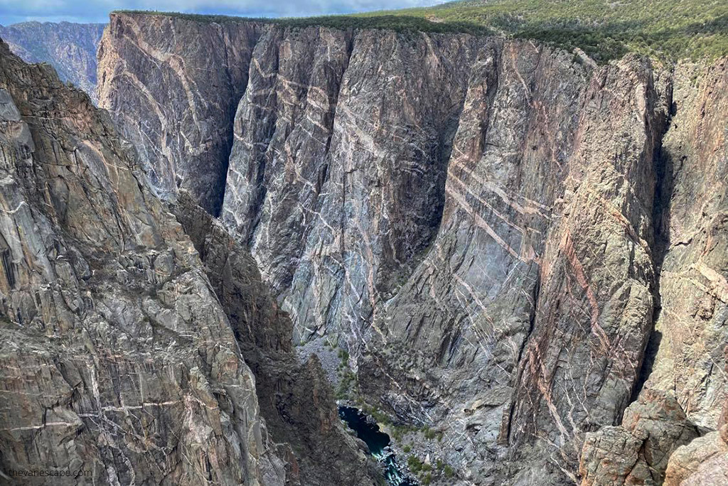
The park contains 12 miles (19 km) of the 48-mile (77 km) long Black Canyon of the Gunnison River, making it one of the top 10 smallest US national parks. The park’s Painted Wall is the highest cliff in Colorado, standing 2250 feet (685 meters) from the river to the rim.
The narrowest point of the Black Canyon is only 40 feet (12 m) wide at the bottom river. On the rim, the distance between the South Rim and the North Rim is only 1,100 feet in the narrowest section. From the rim, the walls of the canyon plunge 2,000 feet almost straight down to the Gunnison River, which makes the scenery breathtaking.
The Park Name
The canyon’s name derives from the fact that parts of the gorge receive only 33 minutes of sunlight daily. Black Canyon is very steep and narrow, so some of the walls are hidden in the dark and shadows because sunlight cannot penetrate the bottom of the gorge.
South Rim and North Rim of Black Canyon
The Park contains two parts:
- Black Canyon of the Gunnison South Rim. The south rim entrance is located 15 miles (24 km) east of Montrose.
- Black Canyon of the Gunnison North Rim. The north rim entrance is 11 miles (18 km) south of Crawford and is closed in the winter. It’s open only from mid-April to mid-October.
The Black Canyon is home to black bears, mule deer, golden eagles, and peregrine falcon.
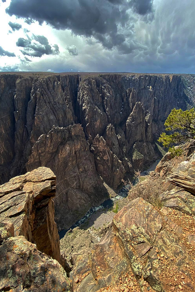
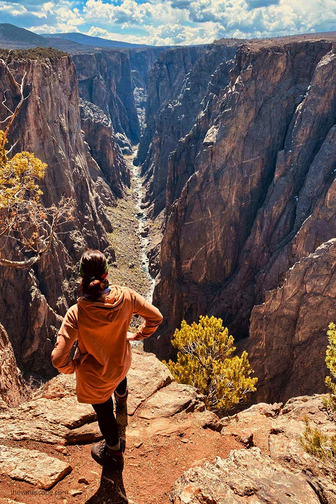
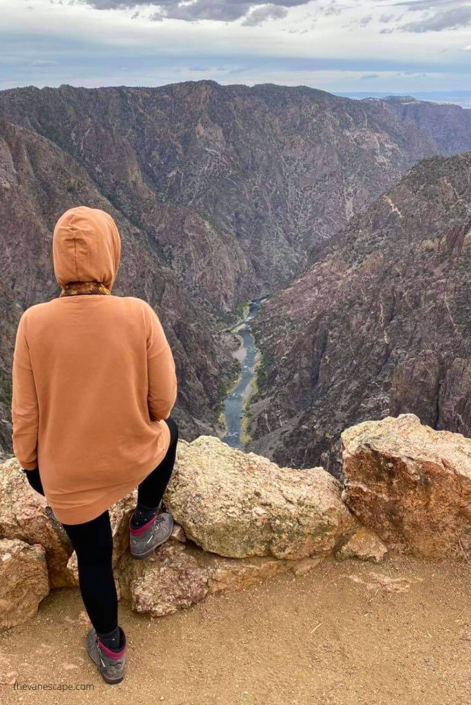
What are the best things to do in Black Canyon of the Gunnison? Standing on the rim of the Black Canyon gives shivers of emotion. The black abyss stimulates the imagination and makes this place extremely mysterious and stunning.
Black Canyon offers great overlooks, hiking trails, and the ability to descend to the inner of a steep canyon (only for the bravest and most experienced hikers). What’s more, you can experience an adrenaline-pumping rafting trip, making the Park extremely attractive.
However, the park is often underestimated. In 2019, the Black Canyon only received 430,000 visitors. So, it’s not only the least visited park in Colorado but also one of the least visited parks in the entire United States. There are no crowds, so add it to your Colorado itinerary.
How Long To Spend at Black Canyon of the Gunnison?
The Black Canyon is not a big park, so you can visit it in one day. But consider that the distance between North Rim and South Rim is considerable. North Rim Ranger Station to South Rim Visitor Center is 80 miles and about 2 hours of driving. And you need at least 3-4 hours for each part.
You can check how we split the visit for two days in our ready-to-go Colorado Itinerary (check Day 5 and Day 8). Ideally, reserve at least one day to visit each part of the park.
However, if you plan on going the Inner Canyon route or rafting, book an extra day or two for each activity. If you plan hiking, be sure to pack the map of Black Canyon.
If you only have half a day to visit the park, choose South Rim. It is more representative, and park access is much easier.
Black Canyon of the Gunnison Weather
What is the best time of the year to visit the park? The best time for your trip is from mid-April to mid-October when both parts of the park are open. If you plan your visit in other months, you will only see the southern part of the park.
The weather will also be the best in late spring and summer. There are the sunniest days, so there is a chance that more light will illuminate the dark bottom of the canyon. Because the canyon is narrow and in shadow, you will have the best light for observing and photographing its walls and bottom from the viewpoints around noon when the sun is at its highest.
Most important is to know that the Black Canyon of the Gunnison National Park has a large elevation difference between the canyon rim and the Gunnison River below. So, you must be prepared for a large difference in temperatures, especially if you plan some adventure as an inner canyon hike or rafting.
At the bottom of the gorge, most of the day is shaded. It can be much colder and more humid. At the rim can be windy. Black Canyon remains dry most of the year, with thunderstorms in the summer and occasional snow in the winter. But its north rim is closed from mid-October to mid-April due to snow.
The average high temperature in April is 56.1 °F (13.4 °C), in May 66.4 °F (19.1°C). The hottest month is July, with an average of 82.1 °F (27.8°C). Warm and nice is also September 72.4 °F (22.4°C). The coldest months are December, with an average low of 13.1 °F (−10.5°C) and January with 12.9 °F (−10.6°C).
But it’s best to check road status, current conditions, and weather alerts on the park’s official website before you travel.
How To Get To Black Canyon of the Gunnison?
From Denver to Black Canyon of the Gunnison is about 255 miles and 5 hours of driving via I-70 W. The closest major airport and the large city is Grand Junction. From Grand Junction is 84 miles and 1 hour 45 minutes of driving to North Rim and 75 miles and 1 hour and 30 minutes of driving to South Rim.
How To Get To the South Rim of Black Canyon of the Gunnison?
The closest town to Black Canyon of the Gunnison South Rim is Montrose. From Montrose, take US-50 E and CO-347. It’s only 15 miles and 25 minutes of driving to the South Rim Visitor Center. This part is open year-round but always check current alerts on the park’s website.
The South Rim Road is closed beyond the Visitor Center in winter. But you can still enjoy this part of the park on foot, on snowshoeing or ski.
How To Get To the North Rim of Black Canyon of the Gunnison?
The closest town to Black Canyon of the Gunnison North Rim is Hotchkiss. From Hotchkiss via Crawford is only 24 miles to the North Rim. The driving time is about 40 minutes. Take CO-92 E and then Black Canyon Rd. There is no paved road in the North Rim. It is only a gravel road, but a regular car is enough for it.
You don’t need a 4×4. Please, remember that this road and part of the park are closed for winter. From Hotchkiss is also possible to take a whitewater rafting adventure down the Gunnison River.
Black Canyon of the Gunnison Map
You don’t need a detailed map if you plan a short visit to the park and several hiking trails available at the rim. The brochure map from the visitor center and our tips should be enough.
But if you like extreme and difficult hikes and want to go down to the bottom of the gorge, be sure to take a good paper map with you. There is no marked trail on the inner canyon route, is a wilderness area. There is no phone coverage at the park as well. These inner canyon routes are technically difficult descents on steep walls.
Therefore, get a Black Canyon of the Gunnison map to have an accurate reconnaissance of the area.
It’s also worth reading the Essential Guide To Black Canyon of Gunnison National Park by Colorado Mountain Club Jewels of the Rockies. You will find detailed route descriptions for hikers and climbers with photos, maps, and elevation profiles.
Where to Stay When Visiting Black Canyon of the Gunnison?
Camping near Black Canyon of the Gunnison National Park
They are two campings in Black Canyon of the Gunnison National Park and one near the Black Canyon (at the bottom of the abyss), but you must drive through the park to get there. All are in remote areas, so prepare for no electricity, phone coverage, or services.
Pack yourself carefully because the weather in the park can change rapidly. Remember to pack enough food and water. There are no shops or restaurants in the park. Our Day Hiking Packing List and Car Camping Checklist can be helpful in your preparations.
North Rim Campground
The North Rim is a more remote area. There is no cell phone reception or internet connection. It’s important to know that this campground is 8,000 feet in elevation. The weather is unpredictable, so prepare yourself for 3-season camping, even in summer. The campground is simple and has 13 sites. So, it fills quickly during the summer, especially on weekends. No electricity or showers. Only vault toilet.
It is first-come, first-served all season from mid-April to mid-October. The sites are spacious and spread out among pinyon and juniper trees. The maximum combined length of the RV, car, and trailer is 22 feet. The nightly camping fee at the North Rim is $16.00. For more information and operating hours, check on the website.
South Rim Campground
The South Rim Campground is located one mile from the South Rim Visitor Center. It’s much bigger. It offers a total of 88 sites (23 with electric hookups). From mid-May to mid-September, you must have a reservation. So, book your stay in advance. In other months it is first come, first served.
The sites are fairly close together. Water is shut off during the cold months. Special restrictions are in place in summer to prevent deer/dog conflicts. So, check the rules before your visit. Also, prepare yourself for 3-season camping, even in summer. The campground is often windy.
East Portal Campground
The East Portal Campground is located at the bottom of the canyon along the Gunnison River. It is located within Curecanti National Recreation Area but is only accessible from Black Canyon of the Gunnison National Park. So, you must pay for the campground ($16.00 per night ) and for the entrance to the park (the entrance fee to the park is $30).
So, it’s worth having an Annual Pass. It is a small campground with 15 sites, first-come, first-served. East Portal is closed in winter. Vehicles exceeding 22 feet in length (including trailers) are not permitted on East Portal Road.
Hotels near Black Canyon of the Gunnison National Park
If you plan to visit North Rim, stay in Hotchkiss or Delta. In Delta, you will surely find better prices and accommodation standards. If you plan to visit the South Rim of Black Canyon, stay in Montrose. It’s a charming town with a good selection of loading and restaurants as well.
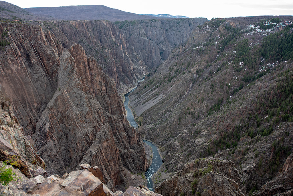
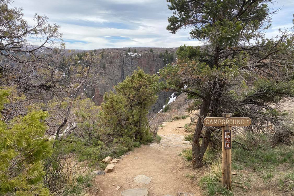
15 Best Things To Do in Black Canyon of the Gunnison North Rim
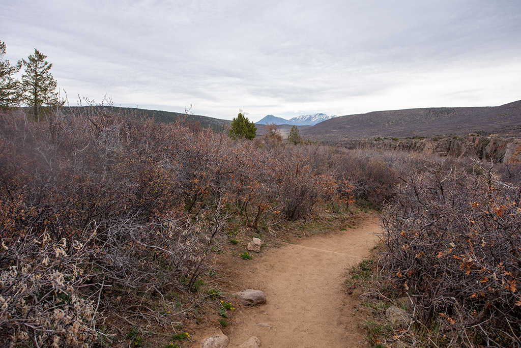
We start with the North Rim, a less-known, more remote, wilder, and highly underrated part of the Black Canyon of Gunnison National Park. There are few tourists here, but the views are breathtaking. And it’s really worth seeing this part of the park.
Drive North Rim Drive Road
It is a gravel road but suitable for any vehicle. It’s only 4,5 miles long. There are only five overlooks to visit on North Rim Drive Road. What’s more, it’s is a short and easy walk from the parking spots to each overlook. So, 1-1,5 hours should be enough to do this scenic drive with stops for photos.
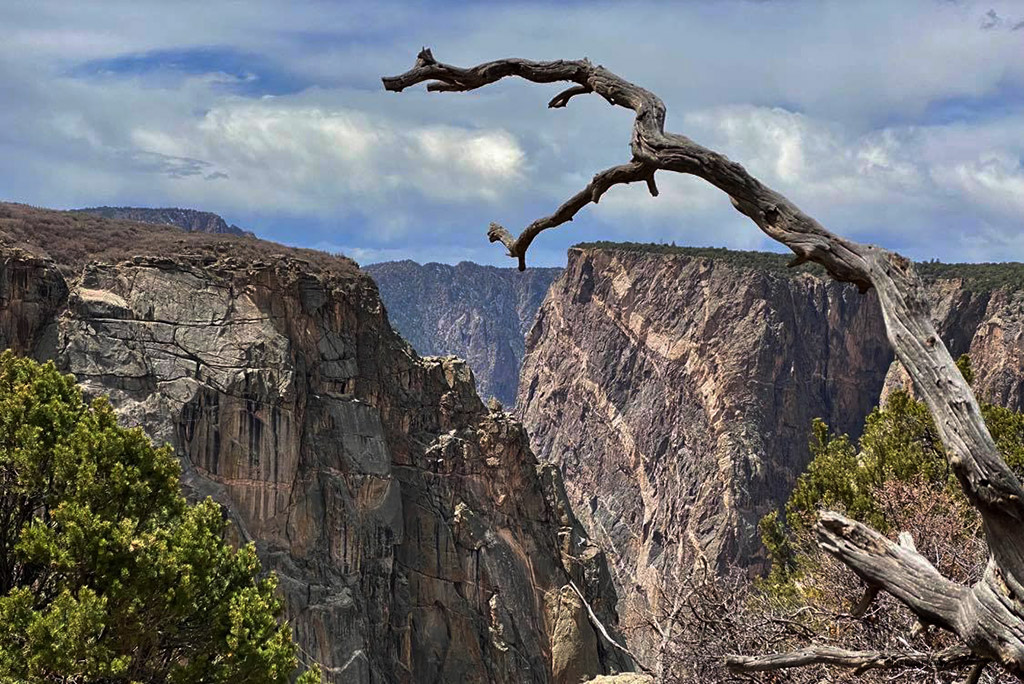
Take Pictures of the Black Canyon of the Gunnison
You have 5 overlooks, so it’s worth stopping on each to take some pictures. It takes you 1-3 minutes easy walk to each viewpoint from the parking spot. The five overlooks are:
- The Narrows. This spot offers great views along the Black Canyon at one of its narrowest points as its name point.
- Balanced Rock. You will see a huge, balanced boulder above the Gunnison River from this overlook.
- Big Island. This overlook offers a nice photo spot for the Gunnison River. The lonely rock looks like an island in the sea.
- Island Peaks View. It is an exciting viewpoint as you can see many South Rim. So you see how narrow the gorge is. Looking northwest, you can spot the South Rim Visitor Center. What’s more, you can see how steep the hiking trail to the inner canyon is. Because from this viewpoint, you can see the Gunnison Route from the South Rim. It is one of the easiest and most popular routes to the inner canyon.
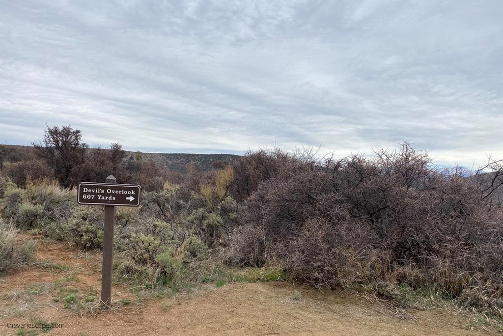
- Kneeling Camel View. You will see a camel when you stand on this point and look left towards the river. It kneels comfortably above the rim and looks out at this stunning view. It’s the last viewpoint, and the road ends so that you will drive back.
Take One of the Best Hikes in Black Canyon of the Gunnison North Rim
If you have more than two hours to visit the North Rim of the park, it is worth going on one of the hiking trails. There are 4 hiking trails on this rim. Below we present them briefly and suggest the best hikes in the Black Canyon of the Gunnison National Park.
Hike to Exclamation Point
Difficulty: Easy to Moderate | Distance: 3 miles round trip| Time required: 1,5 hours
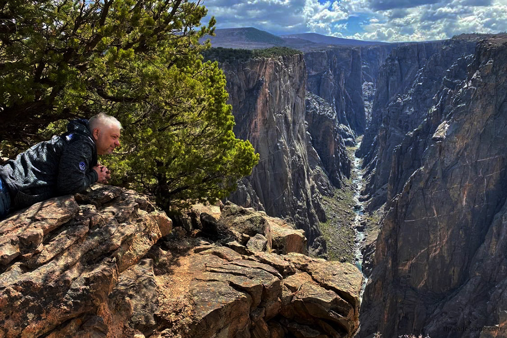
Exclamation Point is our number one on both rims of Black Canyon. In our opinion is one of the best hikes in the Black Canyon of the Gunnison National Park. Exclamation Point is a part of the longer North Vista Trail. The second part is Green Mountain Trail.
Trailhead is located at the North Rim Ranger Station. After passing through an area of sage and oak brush, the trail meanders in a pinyon and juniper forest along the canyon’s rim. From the Exclamation Point is the best inner-canyon view. One of the most dramatic and thrilling views of Black Canyon. Pets are not allowed.
Chasm View Nature Trail
Difficulty: Easy | Distance: 1/3 mile round trip | Time required: 20 minutes
It’s an easy and short hike that starts at the North Rim Campground. One of the best hikes in the Black Canyon. This trail is located at the end of the one-way campground loop. After a short distance, the trail breaks out of the pinyon and juniper forest at the North Chasm View, some 1800 feet above the river. The trail reaches a second overlook with excellent views of Painted Wall and Serpent Point.
In our opinion, it offers stunning views of the Painted Wall. The Painted Wall is the tallest cliff in Colorado at 2,250 feet. You can see people at the overlooks on the South Rim from here. You can also spot swifts, swallows, and raptors. Pets on a leash are allowed.
Green Mountain Trail
Difficulty: Strenuous | Distance: 7 miles round trip | Time required: 3 – 4 hours
It’s the second part of the North Vista Trail. From Exclamation Point, you can continue the hike to Green Mountain. You can admire panoramic vistas, including the San Juan Mountains, Grand Mesa, the Uncompahgre Plateau, and Black Canyon. The total ascent is 1,230 feet. When you reach the peak of Green Mountain, you’ll be standing at 8,546 feet.
It’s a long and pretty strenuous hike, so pack more water and some hiking snacks and food. Trekking poles will be useful on this trail. Wear hiking boots with a good grip. You can check our Day Hiking Packing List to prepare for this adventure. Pets are not allowed.
Deadhorse Trail
Difficulty: Moderate | Distance: 5 miles round trip | Time required: 2,5 – 3,5 hours
This trail starts at the Kneeling Camel Overlook. It enters the Black Canyon of the Gunnison Wilderness Area offers good views of Deadhorse Gulch and East Portal on the Gunnison River, as well as good birding. Pets are not allowed.
Take the Gunnison River Rafting Trip
The Gunnison River Gorge Rafting Trip is a perfect idea for exploring and experiencing the bottom of the gorge with no climbing. It’s an amazing adventure. Colorado is famous for rafting. But Gunnison River is spectacular, so consider this trip.
Explore the Inner Canyon
If you have no climbing experience and technically challenging descents, skip this part of our guide. Don’t take any chances.
If you want to enter the inner canyon, you have three routes on the North Rim to choose from. But, first of all, you MUST HAVE a permit for a hike to the inner canyon. It’s also possible to camp by the river overnight. All routes to the inner canyon on both sides of the park require wilderness use permits.
You can obtain it at the Ranger Station on the North Rim. Permits are free. And they must be obtained on the day of your hike (no reservations). There is a permit self-registration kiosk with instructions when the ranger station is closed. Be sure to complete the permit with accurate and legible information thoroughly.
What to Pack to Inner Canyon?
Whether you choose the inner route from the North or the South Rim, all routes are challenging and require preparation. According to the NPS website, hikers must find their own way and be prepared for self-rescue. So, be sure to pack a well-equipped First-Aid kit. Excellent physical fitness, prior hiking experience, and even some climbing experience are necessary to do these hikes.
There are no maintained or marked trails into the inner canyon. Prepare yourself for these experiences, and pack properly. Pack and check the map, and guide routes to the inner canyon. These hiking trails are also infamous for the abundant poison ivy growing along the trail, 5 feet high in some spots. So be careful. Wear long pants and sleeves. There is also a shade most of the day, so wear layers. Those routes are not for children. Pets are not allowed in the inner canyon wilderness.
Be sure to pack at least 4 liters of water and a water filter or purification tablets. Wear sturdy hiking boots with a perfect grip. Pack high-energy foods, like protein bars, beef jerky, and nuts. Be prepared for rapid weather changes and thunderstorms, so pack rain gear. What’s more, black bears are present in the wilderness.
Remember a good compass, as GPS devices often don’t work in the canyon. Pack a headlamp and an Emergency Sleeping Bag and tent Shelter in case you have trouble getting out of the canyon on the same day.
Below, we present only brief information about the possibilities of the inner route from the North Rim.
S.O.B. Draw
Distance: 1.75 miles (2.8 km) round trip| Time required: 5 hours | Vertical Drop: 1800 feet (549 m)
According to the NPS website, this is the easiest inner canyon route on the North Rim. The trail drops 1,800 feet before arriving at the Gunnison River. But protect yourself against the poison ivy. Wear long sleeves and long pants. The route begins at the access ladder along the fence line just east of the North Rim Campground.
Long Draw
Distance: 1 mile (1.6 km) round trip| Time required: 4,5 hours | Vertical Drop: 1800 feet (549 m)
This route is also called Devil’s Slide and takes you to the narrowest parts of the canyon. There is plenty of poison ivy along the bottom of this route. The route starts at Balanced Rock Overlook.
Slide Draw
Distance: 1 mile (1.6 km) round trip| Time required: 4,5 hours | Vertical Drop: 1800 feet (549 m)
This route starts at the Kneeling Camel View area. And it’s extremely steep and the most potentially dangerous due to loose rock and poor footing.
Admire Needle Rock
On the way to the North Rim of Black Canyon of the Gunnison, you can spot Needle Rock. It’s a fabulous rock formation which is located northeast of Crawford. So, it’s great to add a Needle Rock Natural Area short photos stop to your itinerary to enjoy the view.
Best Things To Do in Black Canyon of the Gunnison South Rim
The South Rim of the Black Canyon of the Gunnison National Park has many more visitors but is still underrated among national parks. You have easier access to South Rim from Montrose. The road is paved, and the park is open year-round. The South Rim Road is closed beyond the Visitor Center in winter.
But you can still visit it during winter on foot, ski, or snowshoeing. What’s more, you have one of the best views of Black Canyon just to the visitor center (Gunnison Point). So, if you can choose only one part of the park, South Rim is more representative.
Drive South Rim Route
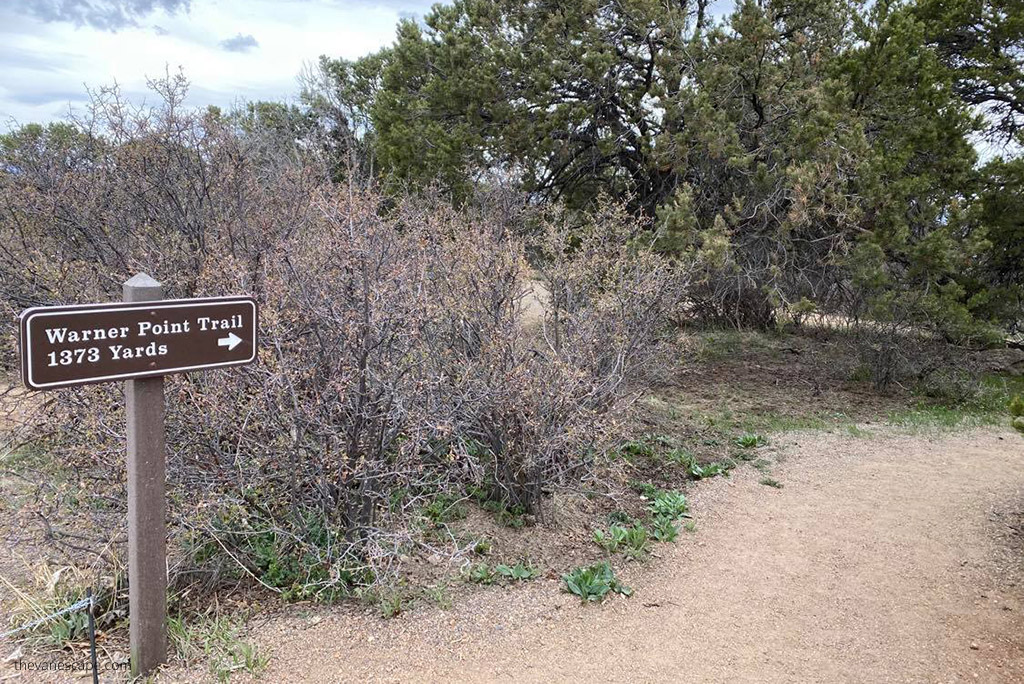
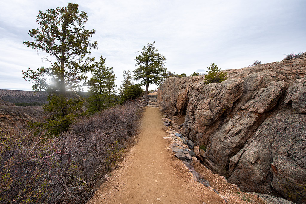
South Rim Road is paved, 7 miles long, and has 12 overlooks. Some viewpoints are close to parking spots, but some require 5 -12 minutes long walking. The longest walk is to Warner Point – 1373 yards one way. Most are located about 1/3 of a mile from the road.
So you need at least 3-4 hours to do all overlooks and enjoy the scenery. The first overlook is Tomichi Point, just before you reach the South Rim visitor center. The road ends at High Point.
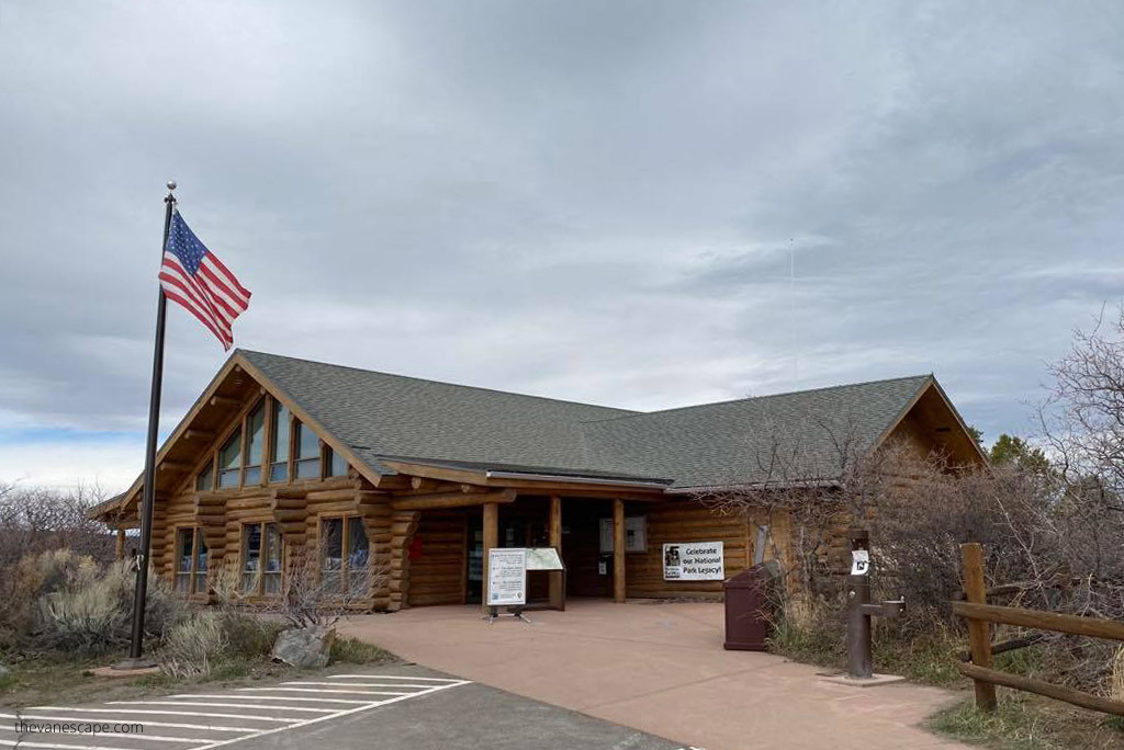
Visit South Rim Visitor Center
It’s worth stopping at the visitor center to grab a map and check the weather. If you plan to go to the inner canyon, you can pick up your permit and talk to rangers about the current weather situation and conditions on the routes. Next to the visitor center, you have one of the best overlooks – Gunnison Point.
Take Pictures of Black Canyon from the South Rim
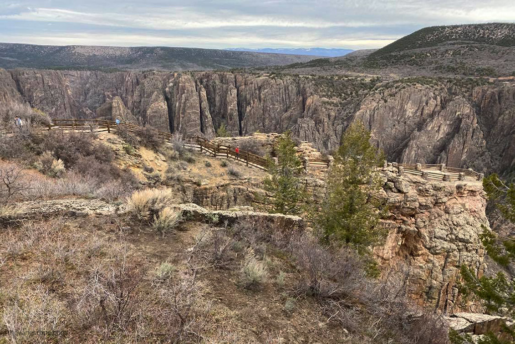
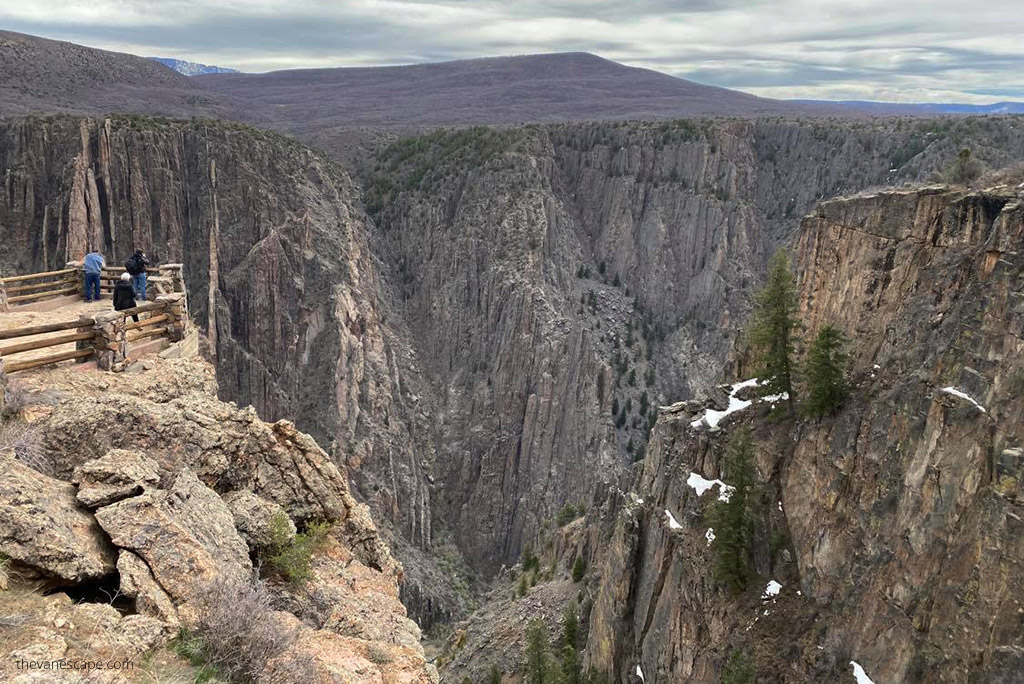
Below we list all 12 viewpoints on the route from start to finish. But if you do not have time to stop at each of them, in our opinion, the best overlooks to take pictures on the South Rim of Black Canyon are Gunnison Point, Chasm View, Painted Wall, Cedar Point Nature Trail, and Dragon Point.

12 overlooks Black Canyon South Rim are:
- Tomichi Point
- Gunnison Point
- Pulpit Rock Overlook
- Cross Fissures View
- Rock Point
- Devils Lookout
- Chasm View
- Painted Wall
- Cedar Point Nature Trail
- Dragon Point
- Sunset View
- High Point
Take One of the Best Hikes in Black Canyon of the Gunnison South Rim
If you have more time to visit, you can choose one of the hikes along the South Rim. However, as mentioned above, short walks are also necessary to reach some of the viewpoints. The best hikes in Black Canyon South Rim are:
Rim Rock Nature Trail
Difficulty: Easy to Moderate | Distance: 2 miles round trip | Time required: 45 minutes – 1 hour
This hike starts near the entrance to Campground Loop C and ends at the South Rim Visitor Center. It’s a rather easy and flat path along the rim. You can admire the steep walls of the canyon and Gunnison River at the bottom. For us, it’s one of the best hikes on the South Rim.
Cedar Point Nature Trail
Difficulty: Easy | Distance: 2/3 mile round trip | Time required: 30 minutes
This trail leads to one of the best overlooks on the South Rim. During this walk, you can admire local flora, as guideposts describe the various plants along the way. From the overlooks, you can see the river over 2,000 feet below, with the famous Painted Wall, the tallest cliff in Colorado (2,250 ft.), and rock islands jutting up from the canyon depths. Pets are allowed on leashes.
Warner Point Nature Trail
Difficulty: Moderate | Distance: 1,5 miles round trip | Time required: 1 hour
Warner Point Trail is located at the end of South Rim Road, near the High Point overlook. What’s important is that most of the hike doesn’t offer views of the Black Canyon. This hike offers views over the San Juan Mountain Range and Uncompahgre Valley. At the end of the trail, you see the Gunnison River, so if you don’t have enough time, choose another one with Black Canyon views.
Uplands Trail
Difficulty: Easy | Distance: 2 miles round trip | Time required: 45 minutes – 1 hour
It’s easy to hike, but it’s not along the rim, so you can’t admire the canyon from it. However, you can spot some wildlife early in the morning or in the evening, and it offers views of the West Elk Mountains. Pets are not allowed.
Oak Flat Loop Trail
Difficulty: Strenuous | Distance: 2 miles round trip | Time required: 1,5 – 2 hours
This is the most strenuous hike along the rim. It offers variety to the hiker who would like to explore below the rim without taking on the challenge of hiking to the inner canyon of the river. The trail is narrow in places and traverses some steep slopes. Pets are not allowed. The trail begins near the Visitor Center.
Explore the Inner Canyon of the Gunnison
If you have a lot of experience hiking in rough terrain and great physical condition, you might consider hiking down to the bottom of the canyon. Remember that these are not marked trails. They are challenging descents to the inner canyon.
You MUST HAVE Wilderness Use Permits. Check the regulations and rules for obtaining permits on the official website. Sometimes you need to pick up your permit the day before your hike, so reserve at least 2 days for this adventure.
Check out our tips above for the North Rim section to get well-prepared for your adventure.
Gunnison Route
Distance: 1.5 miles (1.6 km) round trip| Time required: 3,5 hours | Vertical Drop: 1800 feet (549 m)
This route is the easiest and most popular to the inner canyon. But it is still very strenuous. It begins at the South Rim Visitor Center. Follow the Oak Flat Trail for 1/3 mile, down the first few switchbacks to a sign “Wilderness Permit Required.” There is a steep descent to the chain down the drainage. An 80-foot chain is located 1/3 of the way down.
Tomichi Route
Distance: 1 mile (1.6 km) round trip| Time required: 6 hours (4.5 hours, or triple the descent time)| Vertical Drop: 1960 feet (597 m)
Tomichi Route is the steepest South Rim route and is extremely difficult. The entire length of the route is loose rock and receives full sun exposure. Several steep inclines near the top of the route require scrambling. To get this route, park at Tomichi Point overlook. Take the Rim Rock Trail (near Loop C at the campground) to post #13. This is the start of the Tomichi Route.
Warner Route
Distance: 2.75 miles (4.4 km) round trip| Time required: 6,5 hours | Vertical Drop: 2722 feet (829 m)
This is the longest route, and NPS suggested overnight camping at the bottom. The bottom of this route takes you to a wider point in the canyon, which offers great fishing opportunities. This route starts at Warner Point Nature Trail. Walk this trail and find past post #13. Look for a large Utah serviceberry bush on the left marked with a small silver sign titled “Serviceberry Bush.” This is the start of the Warner Route.
Drive East Portal Road
From South Rim is also possible to get to the Gunnison River by car. The East Portal Road is 7 miles long, and it starts next to the park entrance station and ends at the Crystal Dam. But it is extremely steep with turns and 16% grades in some spots. Vehicles over 22 feet are prohibited. But check before your visit if it’s open.
Go Fishing in Black Canyon
Fishing is possible on the Gunnison River, but you must have a permit and follow all rules. You can see the details on the official website.
Spot Wildlife
Black Canyon of the Gunnison National Park is home to coyotes, elk, magpies, eagles, mule deer, bears, and more.
Kayak and Rafting in the Gunnison River
Expert kayakers find the Gunnison River through the park an arduous challenge. So, consider rather a kayak or rafting trip in the area. Self-rafting is not possible in the canyon. You can do it only as an organized trip. Kayakers run the river at their own risk. So, before taking this adventure, ask a ranger at the visitor center about current river conditions.
I really appreciate that you have given such a comprehensive breakdown of what to expect. Also it’s nice to know that the park is small enough for us to see in a day. Will add this to our Colorado itinerary for sure! those narrows look like we need to see them in person
I really appreciate that you have given such a comprehensive breakdown of what to expect. Also it’s nice to know that the park is small enough for us to see in a day. Will add this to our Colorado itinerary for sure! those narrows look like we need to see them in person!
Oh my God I have never seen a canyon that is black. That looks stunning. I have never been to Colorado but have it on my list for sure. I will surely visit the Black Canyon. And I will add those hiking trails on my list. I will visit it for longer period so I can spend a few days there walking and exploring the trails. And will add kayaking to my list too.
Those are stunning cliffs and rocks for sure. I will add this National Park to my to-go-list. Good to know, that there are not too many tourists. I would definitely spend a few days to go hiking and also go for a rafting tour. Do you know if there are any rock climbing routes in the park?
Great guide for Gunnison National Park, with lots of useful information. I’d love to visit it someday. Those black rock walls of the canyon surely look like from another planet. Very arid, yet beautiful landscape.There seem to be quite a few interesting things to do around, like kayaking, hiking or fishing. Not sure I’d like to take the Inner route and camp at the bottom of the canyon. Especially if you say there are difficult descents. I’d rather take the Oak Flat loop which is only 2 hours long.
Gunnison River spot looks truly spectacular. Not being a great hiking person would love to do some trails like Warner Point Nature Trail, Oak Flat Loop Trail & Uplands Trail which are short. The back color of the Canyon is such a pleasure to the eyes.
If we make it south of the border on our coming trip west, we would definitely like to spend a little time in Colorado. Your posts are building my list of places to see. Black Canyon at Gunnison will get added to the list. Although we might be a bit late to see the North Rim before it closes for the winter. We would certainly want to time our visit and viewing location to catch the 33 minutes of sunlight when the canyon may be lit. And if weather is with us, it would be great to hike to Exclamation Point.
I’ve never heard of the Black Canyon but it sounds like such an interesting place to visit. Love that they’ve calculated that it only gets 33 minutes of sunlight a day. The hike to Exclamation Point sounds fascinating too.
Dramatic vistas, the wilderness, the landscape — the scene is set for adventure. Indeed worthy of a national park status! I know that it’s a magnificent landmark, but looking at these photos gave me a unique perspective of it.
Black Canyon seems like just my kinda place. I LOVE hiking/trekking in the mountains. Hiking on the mentioned trails is something I would totally look forward to. Pictures looks amazing!
I live pretty close to Colorado (well, their neighbor state lol) and I dont recall a lot of people talking about Black Canyon – definitely another place to add to my bucket list now!
This canyon looks impressive and almost nauseating in the pictures – how must it be as you stand there looking down!?! I used to be afraid of heights, but it’s getting slightly better. However, I’m not sure if I could deal with this. On the other hand, I find it totally fascinating and would love to witness it in person. Anyway, as long as there are no public vehicles going to these places, I’m safe….since I’m not driving 😉
http://semaglupharm.com/# symptoms of semaglutide
http://semaglupharm.com/# Semaglu Pharm
side effects to lipitor: LipiPharm – USA-based pharmacy Lipitor delivery
rosuvastatin 40 [url=https://crestorpharm.com/#]switching from pravastatin to rosuvastatin[/url] CrestorPharm
https://crestorpharm.shop/# crestor 40 mg tablet
https://semaglupharm.com/# SemagluPharm
Lipi Pharm: can lipitor cause fatigue – LipiPharm
semaglutide 2.5 mg: Semaglu Pharm – semaglutide en espaГ±ol
Predni Pharm [url=https://prednipharm.com/#]Predni Pharm[/url] order prednisone
https://semaglupharm.com/# No prescription diabetes meds online
80 mg prednisone daily: PredniPharm – PredniPharm
Semaglu Pharm: rybelsus drug interactions – SemagluPharm
https://semaglupharm.com/# rybelsus weight loss before and after pictures
Crestor Pharm [url=https://crestorpharm.shop/#]CrestorPharm[/url] crestor mg
http://crestorpharm.com/# CrestorPharm
SemagluPharm: Semaglu Pharm – Semaglu Pharm
https://semaglupharm.com/# Semaglu Pharm
Lipi Pharm: USA-based pharmacy Lipitor delivery – FDA-approved generic statins online
c2 pill atorvastatin: Cheap Lipitor 10mg / 20mg / 40mg – п»їBuy Lipitor without prescription USA
https://semaglupharm.shop/# Semaglu Pharm
crestor magnesium interaction: astrazeneca crestor – CrestorPharm
prednisone uk price [url=https://prednipharm.shop/#]cost of prednisone 10mg tablets[/url] Predni Pharm
http://lipipharm.com/# Cheap Lipitor 10mg / 20mg / 40mg
CrestorPharm: Order rosuvastatin online legally – CrestorPharm
https://semaglupharm.shop/# rybelsus approved for weight loss
Semaglu Pharm: Semaglu Pharm – Where to buy Semaglutide legally
Online statin therapy without RX [url=https://crestorpharm.com/#]Crestor Pharm[/url] CrestorPharm
https://semaglupharm.com/# Semaglu Pharm
does semaglutide lower blood pressure: can you stop rybelsus cold turkey – Rybelsus online pharmacy reviews
Lipi Pharm: atorvastatin 10 mg price without insurance – Generic Lipitor fast delivery
Crestor home delivery USA [url=http://crestorpharm.com/#]what happens if you take antacids with crestor[/url] Crestor Pharm
https://lipipharm.com/# atorvastatin 10
https://semaglupharm.com/# Buy Rybelsus online USA
Lipi Pharm: Lipi Pharm – LipiPharm
Crestor Pharm: Crestor Pharm – Order rosuvastatin online legally
lipitor inventor [url=http://lipipharm.com/#]Generic Lipitor fast delivery[/url] Lipi Pharm
http://semaglupharm.com/# puedo tomar rybelsus si no tengo diabetes
CrestorPharm: CrestorPharm – CrestorPharm
SemagluPharm [url=https://semaglupharm.shop/#]Semaglu Pharm[/url] No prescription diabetes meds online
https://semaglupharm.com/# SemagluPharm
prednisone without prescription 10mg: prednisone in mexico – Predni Pharm
http://lipipharm.com/# п»їBuy Lipitor without prescription USA
Lipi Pharm: п»їBuy Lipitor without prescription USA – LipiPharm
rosuvastatin and ezetimibe [url=http://crestorpharm.com/#]Crestor Pharm[/url] Order rosuvastatin online legally
https://semaglupharm.com/# Semaglu Pharm
Predni Pharm: online prednisone – Predni Pharm
https://semaglupharm.com/# Semaglu Pharm
semaglutide long term side effects: Online pharmacy Rybelsus – Semaglu Pharm
Semaglu Pharm [url=http://semaglupharm.com/#]microdosing semaglutide chart[/url] Where to buy Semaglutide legally
Crestor Pharm: CrestorPharm – CrestorPharm
http://lipipharm.com/# LipiPharm
https://semaglupharm.com/# Affordable Rybelsus price
lipitor grapefruit: how to take lipitor – LipiPharm
prednisone 50 mg buy [url=https://prednipharm.shop/#]cortisol prednisone[/url] average cost of prednisone
rybelsus (semaglutide tablets): rybelsus insomnia – SemagluPharm
http://medsfrommexico.com/# mexican drugstore online
Meds From Mexico: purple pharmacy mexico price list – reputable mexican pharmacies online
canadian drug stores [url=https://canadapharmglobal.shop/#]legitimate canadian pharmacy[/url] canadian pharmacy no scripts
https://medsfrommexico.com/# pharmacies in mexico that ship to usa
https://indiapharmglobal.shop/# India Pharm Global
India Pharm Global: mail order pharmacy india – world pharmacy india
purple pharmacy mexico price list [url=https://medsfrommexico.shop/#]Meds From Mexico[/url] mexico drug stores pharmacies
https://indiapharmglobal.shop/# India Pharm Global
pharmacies in mexico that ship to usa: Meds From Mexico – Meds From Mexico
pharmacies in mexico that ship to usa [url=https://medsfrommexico.shop/#]Meds From Mexico[/url] buying from online mexican pharmacy
https://canadapharmglobal.shop/# canadian pharmacy 24
http://indiapharmglobal.com/# indian pharmacy paypal
recommended canadian pharmacies [url=https://canadapharmglobal.shop/#]canadian discount pharmacy[/url] canadian family pharmacy
reputable indian online pharmacy: India Pharm Global – indian pharmacy paypal
https://indiapharmglobal.com/# India Pharm Global
Meds From Mexico [url=https://medsfrommexico.com/#]Meds From Mexico[/url] Meds From Mexico
top 10 pharmacies in india: best india pharmacy – reputable indian online pharmacy
https://indiapharmglobal.shop/# India Pharm Global
https://canadapharmglobal.com/# canadian world pharmacy
http://canadapharmglobal.com/# online canadian pharmacy review
buying from online mexican pharmacy [url=https://medsfrommexico.com/#]Meds From Mexico[/url] mexico drug stores pharmacies
medicine in mexico pharmacies: mexican online pharmacies prescription drugs – mexican mail order pharmacies
http://canadapharmglobal.com/# canadian online pharmacy reviews
canadian pharmacy online: canadian pharmacies that deliver to the us – pharmacy wholesalers canada
Meds From Mexico [url=https://medsfrommexico.shop/#]Meds From Mexico[/url] Meds From Mexico
Meds From Mexico: mexico pharmacies prescription drugs – п»їbest mexican online pharmacies
https://canadapharmglobal.com/# legal to buy prescription drugs from canada
https://medsfrommexico.com/# Meds From Mexico
buying drugs from canada: Canada Pharm Global – safe reliable canadian pharmacy
Meds From Mexico [url=https://medsfrommexico.shop/#]best online pharmacies in mexico[/url] pharmacies in mexico that ship to usa
buy drugs from canada: Canada Pharm Global – precription drugs from canada
http://medsfrommexico.com/# mexican online pharmacies prescription drugs
Meds From Mexico: buying from online mexican pharmacy – buying prescription drugs in mexico
best online pharmacy india [url=http://indiapharmglobal.com/#]reputable indian pharmacies[/url] india pharmacy
https://canadapharmglobal.shop/# best canadian pharmacy online
canadian pharmacy ltd: Canada Pharm Global – legit canadian pharmacy
https://svenskapharma.shop/# schampo mot svamp på kroppen
Svenska Pharma [url=https://svenskapharma.shop/#]köp receptbelagd medicin online[/url] Svenska Pharma
EFarmaciaIt: EFarmaciaIt – EFarmaciaIt
http://raskapotek.com/# h2 blokker apotek
kolla recept på apotek [url=http://svenskapharma.com/#]snacks när man är sjuk[/url] köpa glasögon online
https://efarmaciait.shop/# EFarmaciaIt
como comprar ozempic: Papa Farma – nombre de farmacias
https://efarmaciait.com/# EFarmaciaIt
handla billigt på nätet [url=https://svenskapharma.com/#]apotek kondomer[/url] naproxen köpa
https://papafarma.shop/# Papa Farma
krage hund apotek: Svenska Pharma – Svenska Pharma
http://raskapotek.com/# Rask Apotek
Rask Apotek [url=https://raskapotek.com/#]Rask Apotek[/url] hudormer nese apotek
https://svenskapharma.shop/# mins recept
https://efarmaciait.com/# EFarmaciaIt
Svenska Pharma: Svenska Pharma – Svenska Pharma
Rask Apotek: Rask Apotek – Rask Apotek
http://svenskapharma.com/# Svenska Pharma
http://svenskapharma.com/# gua sha – apotek
finasteride apotek [url=http://svenskapharma.com/#]Svenska Pharma[/url] hur stavas välkommen
Svenska Pharma: p piller apotek – Svenska Pharma
antica farmacia orlandi ordini: gentamicina crema bambini – EFarmaciaIt
http://papafarma.com/# pharmacy malaga
apotek inloggning [url=https://svenskapharma.com/#]apotek symbol orm[/url] branschavtal apotek
sykepleier jobb apotek: Rask Apotek – hurtigtest apotek
kalsiumkarbonat apotek: Гёreskyll apotek – korona test apotek
https://papafarma.shop/# lГnea directa reseГ±as google
https://svenskapharma.shop/# medicin gratis barn
Rask Apotek [url=https://raskapotek.com/#]covid test apotek[/url] Rask Apotek
para comprar: para que sirve un dolmen – Papa Farma
EFarmaciaIt: ovixan crema come si usa – EFarmaciaIt
https://raskapotek.shop/# negleklipper apotek
leniref opinioni [url=https://efarmaciait.com/#]EFarmaciaIt[/url] zineryt a cosa serve
kolesterol test apotek: Rask Apotek – Rask Apotek
apotek nett: propolis apotek – fullmaktsskjema apotek
https://raskapotek.com/# apotek votter
orale significato [url=https://efarmaciait.shop/#]EFarmaciaIt[/url] farmacia italy
Rask Apotek: Rask Apotek – Rask Apotek
EFarmaciaIt: EFarmaciaIt – EFarmaciaIt
https://papafarma.shop/# papilla de platano
omega 3 in gocce per adulti [url=http://efarmaciait.com/#]etoricoxib a cosa serve[/url] EFarmaciaIt
http://svenskapharma.com/# bäckenbälte apotek
crema de cannabi para el dolor opiniones: oferta dodot sensitive talla 4 – Papa Farma
https://svenskapharma.shop/# Svenska Pharma
Rask Apotek: kolloidalt sГёlv apotek – Rask Apotek
diflucan 200 prezzo con ricetta [url=https://efarmaciait.com/#]farmacieonlinesicure[/url] EFarmaciaIt
https://pharmaconfiance.shop/# Pharma Confiance
PharmaConnectUSA [url=https://pharmaconnectusa.com/#]parlodel online pharmacy[/url] Pharma Connect USA
MedicijnPunt: Medicijn Punt – online apotheek goedkoper
https://pharmajetzt.com/# PharmaJetzt
https://pharmaconfiance.shop/# pharmacie en ligne viagra avec ordonnance
Medicijn Punt [url=https://medicijnpunt.com/#]medicatie apotheker[/url] Medicijn Punt
medicatielijst apotheek: MedicijnPunt – online medicijnen kopen
https://pharmaconfiance.shop/# Pharma Confiance
http://pharmajetzt.com/# Pharma Jetzt
24 hour pharmacy [url=http://pharmaconnectusa.com/#]PharmaConnectUSA[/url] PharmaConnectUSA
PharmaConnectUSA: Pharma Connect USA – PharmaConnectUSA
viagra 100 mg prix france: meilleur god ceinture – caudalie anti ride 60 millions
https://pharmajetzt.shop/# shop aphotheke
Pharma Connect USA: Pharma Connect USA – Pharma Connect USA
Medicijn Punt [url=https://medicijnpunt.com/#]uw apotheek[/url] MedicijnPunt
PharmaConnectUSA: watch tour de pharmacy online free – femara online pharmacy
https://medicijnpunt.shop/# Medicijn Punt
https://pharmaconnectusa.com/# PharmaConnectUSA
Medicijn Punt [url=http://medicijnpunt.com/#]Medicijn Punt[/url] Medicijn Punt
apotal – ihre versandapotheke: PharmaJetzt – shopp apotheke
https://pharmaconfiance.shop/# Pharma Confiance
PharmaJetzt [url=https://pharmajetzt.com/#]gГјnstig medikamente[/url] Pharma Jetzt
https://medicijnpunt.shop/# apotheek online nederland
generic cialis pharmacy online: PharmaConnectUSA – Pharma Connect USA
peut on Г©changer un mГ©dicament en pharmacie: pharmacie la.plus proche – Pharma Confiance
https://medicijnpunt.shop/# apotheken nederland
apoteken [url=http://pharmajetzt.com/#]PharmaJetzt[/url] PharmaJetzt
Pharma Connect USA: generic lexapro online pharmacy – Pharma Connect USA
luitpold apotheke mediherz: Pharma Jetzt – gГјnstige online apotheke auf rechnung
Pharma Confiance [url=https://pharmaconfiance.shop/#]Pharma Confiance[/url] antibiotique naturel en pharmacie
online aporheke: online apotheke deutschland – online medikamente
prendre amoxicilline et doliprane: mГ©dicament metronidazole – piscine de la grГўce de dieu
https://pharmaconfiance.com/# entreprise de livraison de médicaments
https://medicijnpunt.com/# MedicijnPunt
PharmaJetzt [url=https://pharmajetzt.shop/#]PharmaJetzt[/url] PharmaJetzt
thrifty drug store: Pharma Connect USA – spain pharmacy viagra
https://pharmajetzt.com/# apotehke online
nutri pur: pharmacie allemagne – pharmacie de garde aujourd’hui rouen
Pharma Confiance [url=https://pharmaconfiance.com/#]pharmacie moins cher en ligne[/url] achat viagra espagne pharmacie
Pharma Confiance: pharmacie de garde lyon 7 aujourd’hui – Pharma Confiance
https://pharmaconfiance.shop/# médicament monuril
PharmaConnectUSA: Pharma Connect USA – PharmaConnectUSA
MedicijnPunt [url=http://medicijnpunt.com/#]Medicijn Punt[/url] online apotheek zonder recept
https://medicijnpunt.com/# pharma online
medikame: medikamente online bestellen mit rezept – PharmaJetzt
http://medicijnpunt.com/# pharmacy online
shop a: Pharma Jetzt – PharmaJetzt
Pharma Confiance [url=https://pharmaconfiance.com/#]Pharma Confiance[/url] pharmacie duteil
online us pharmacy viagra: rx health pharmacy – Pharma Connect USA
https://medicijnpunt.com/# MedicijnPunt
bas de contention taille 7: Pharma Confiance – pharmacie discount en ligne
online apotheke gГјnstig [url=http://pharmajetzt.com/#]medicine online[/url] Pharma Jetzt
Pharma Jetzt: meine online apotheke – PharmaJetzt
https://pharmaconfiance.com/# pharmacie dante
https://pharmajetzt.com/# PharmaJetzt
Pharma Confiance: Pharma Confiance – viagra homme achat en ligne
online pharmacy store hyderabad [url=https://pharmaconnectusa.com/#]wegmans pharmacy online[/url] PharmaConnectUSA
https://medicijnpunt.com/# Medicijn Punt
netherlands online pharmacy: Medicijn Punt – viata online apotheek
Pharma Confiance: Pharma Confiance – quelle pharmacie
Pharma Connect USA [url=http://pharmaconnectusa.com/#]in house pharmacy propecia[/url] naturxheal family pharmacy & health store-doral
https://pharmajetzt.shop/# apotheke obline
medicatie aanvragen: recept online – online apotheek nederland
http://pharmaconnectusa.com/# inhouse pharmacy baclofen
https://pharmaconnectusa.shop/# PharmaConnectUSA
PharmaJetzt [url=https://pharmajetzt.com/#]Pharma Jetzt[/url] shop apotheke deutschland
MedicijnPunt: medicijnen online kopen – Medicijn Punt
PharmaConnectUSA: percocet pharmacy – humana online pharmacy login
https://pharmajetzt.com/# Pharma Jetzt
shops apotheke [url=http://pharmajetzt.com/#]online apotheken vergleich[/url] onlien apotheke
amoxicilline 500 mg Г partir de quel Гўge: produits de parapharmacie – Pharma Confiance
Pharma Jetzt: apotheken – versand apotheke
https://pharmaconfiance.com/# nez de marche dorГ©
https://medicijnpunt.com/# online apotheek zonder recept
Pharma Confiance [url=http://pharmaconfiance.com/#]Pharma Confiance[/url] Pharma Confiance
Pharma Confiance: Pharma Confiance – tena protection femme
http://pharmaconfiance.com/# lapsa avis
PharmaJetzt [url=https://pharmajetzt.shop/#]medikament kaufen[/url] Pharma Jetzt
Pharma Confiance: Pharma Confiance – Pharma Confiance
Pharma Confiance: amoxicilline bebe – Pharma Confiance
http://pharmajetzt.com/# PharmaJetzt
Какой сегодня праздник [url=https://inforigin.ru]https://inforigin.ru[/url] .
https://pharmaconnectusa.com/# pharmacy online program
История дня [url=istoriamashin.ru]istoriamashin.ru[/url] .
shopp apotheke [url=http://pharmajetzt.com/#]online apotheke schnelle lieferung[/url] PharmaJetzt
Народные приметы [url=http://topoland.ru]http://topoland.ru[/url] .
pharmacy nederlands: medicijnen aanvragen apotheek – afbeelding medicijnen
can you get viagra at the pharmacy: us viagra online pharmacy – Pharma Connect USA
http://pharmaconnectusa.com/# lipitor pharmacy card
pharmaceutical online [url=https://pharmaconnectusa.com/#]Pharma Connect USA[/url] PharmaConnectUSA
viagra pharmacy prices: PharmaConnectUSA – Etodolac
https://pharmaconnectusa.shop/# navarro pharmacy store
PharmaConnectUSA: klonopin online pharmacy reviews – Pharma Connect USA
http://pharmajetzt.com/# Pharma Jetzt
online pharmacy pain meds [url=https://pharmaconnectusa.shop/#]PharmaConnectUSA[/url] Pharma Connect USA
MedicijnPunt: medicijnen kopen online – Medicijn Punt
Погода [url=http://novorjev.ru]http://novorjev.ru[/url] .
Пронедра [url=www.pechory-online.ru/]www.pechory-online.ru/[/url] .
pharmacy online netherlands: Medicijn Punt – online medicijnen kopen zonder recept
https://pharmaconnectusa.com/# cymbalta pharmacy card
medikament online: klack 95 – luitpold apotheke wГјrzburg
Pharma Connect USA: Pharma Connect USA – Pharma Connect USA
apotheek winkel 24 review [url=http://medicijnpunt.com/#]Medicijn Punt[/url] Medicijn Punt
https://medicijnpunt.shop/# Medicijn Punt
https://pharmajetzt.shop/# Pharma Jetzt
pil online bestellen: Medicijn Punt – MedicijnPunt
viagra usa online pharmacy: uk pharmacy online viagra – amlodipine besylate online pharmacy
tour de pharmacy online: effexor online pharmacy – cymbalta pharmacy price
medicatie bestellen apotheek [url=https://medicijnpunt.shop/#]MedicijnPunt[/url] MedicijnPunt
https://pharmaconnectusa.shop/# Pharma Connect USA
online apotheek – gratis verzending: farmacia online – MedicijnPunt
medicijnen online kopen: medicatie online – apotheke nl
http://medicijnpunt.com/# bestellen apotheek
apotheek online nederland: medicatie aanvragen – Medicijn Punt
amoxicilline en sachet [url=https://pharmaconfiance.shop/#]Pharma Confiance[/url] parapharmacie rennes
https://pharmajetzt.com/# Pharma Jetzt
apotheek zonder recept: online apotheek recept – MedicijnPunt
dragon slots casino [url=http://dragonslotscasinos.mobi]http://dragonslotscasinos.mobi[/url] .
dragon link slots online real money [url=https://dragonslotscasinos.net/]dragonslotscasinos.net[/url] .
PharmaJetzt: Pharma Jetzt – PharmaJetzt
MedicijnPunt: medicijnen bestellen zonder recept – mijn medicijn.nl
https://pharmaconnectusa.shop/# Pharma Connect USA
Medicijn Punt [url=https://medicijnpunt.shop/#]Medicijn Punt[/url] medicijnen apotheek
pseudoephedrine kopen in nederland: onlineapotheek – MedicijnPunt
https://medicijnpunt.shop/# apotheek medicijnen bestellen
MedicijnPunt: netherlands pharmacy online – MedicijnPunt
https://pharmajetzt.com/# intenet apotheke
Medicijn Punt: Medicijn Punt – Medicijn Punt
pokiesnet [url=https://thepokiesau.org]pokiesnet[/url] .
dragonslots casino [url=http://www.casinosdragonslots.eu]http://www.casinosdragonslots.eu[/url] .
PharmaConnectUSA: Pharma Connect USA – mtf hormones online pharmacy
The Pokies Australia [url=www.pokiesnet250.com]www.pokiesnet250.com[/url] .
Pharma Connect USA [url=https://pharmaconnectusa.shop/#]PharmaConnectUSA[/url] o reilly pharmacy artane
thepokies net250 [url=http://thepokiesnet250.com/]thepokies net250[/url] .
The Pokies net Australia login [url=http://thepokiesnet101.com/]http://thepokiesnet101.com/[/url] .
medicijnen aanvragen apotheek: medicatie apotheker review – medicijnen aanvragen
Pharma Connect USA: Pharma Connect USA – the peoples pharmacy
http://pharmaconnectusa.com/# cobix generic celebrex pharmacy
https://medicijnpunt.com/# MedicijnPunt
pokies111 [url=https://pokies11.com]https://pokies11.com[/url] .
brooks pharmacy store: Pharma Connect USA – Pharma Connect USA
автоматические гардины для штор [url=elektrokarnizy50.ru]elektrokarnizy50.ru[/url] .
Medicijn Punt [url=https://medicijnpunt.shop/#]internetapotheek spanje[/url] apotheek medicijnen bestellen
pokies106 [url=http://pokies106.com]pokies106[/url] .
Pharma Confiance: ars pharmacie – Pharma Confiance
https://pharmaconnectusa.shop/# lortab pharmacy price
peut-on prendre 2 viagra 50 mg [url=https://pharmaconfiance.shop/#]viagra pour homme prix pharmacie[/url] peut on prendre du ketoprofene avec du doliprane
https://medicijnpunt.com/# MedicijnPunt
apo apotheke online: online-apotheken – Pharma Jetzt
apteka holandia: pharma online – MedicijnPunt
https://pharmaconnectusa.shop/# navarro pharmacy miami
ou se procurer du viagra: pharmacie de garde lyon 3 aujourd’hui – protege slip tena noir
PharmaConnectUSA: PharmaConnectUSA – what pharmacy sells azithromycin
PharmaJetzt [url=https://pharmajetzt.shop/#]PharmaJetzt[/url] shopapothe
https://pharmajetzt.shop/# onlineapotheken
MedicijnPunt: onl8ne drogist – MedicijnPunt
https://pharmaconfiance.shop/# acheter gel douche en gros pas cher
https://pharmaconfiance.shop/# Pharma Confiance
pharmacie moins cher de paris [url=https://pharmaconfiance.com/#]new pharma.fr[/url] crГЁme fucidine sans ordonnance
Pharma Confiance: achat de viagra – Pharma Confiance
Pharma Confiance: quelle est la pharmacie de garde aujourd’hui Г brest – Pharma Confiance
http://indimedsdirect.com/# mail order pharmacy india
TijuanaMeds: TijuanaMeds – п»їbest mexican online pharmacies
TijuanaMeds [url=https://tijuanameds.com/#]TijuanaMeds[/url] TijuanaMeds
http://indimedsdirect.com/# п»їlegitimate online pharmacies india
http://indimedsdirect.com/# Online medicine home delivery
TijuanaMeds: mexico drug stores pharmacies – pharmacies in mexico that ship to usa
mexican drugstore online: buying prescription drugs in mexico – mexican border pharmacies shipping to usa
legit canadian pharmacy [url=https://canrxdirect.shop/#]CanRx Direct[/url] canadian discount pharmacy
https://canrxdirect.shop/# precription drugs from canada